Geolokalisieren

Topografische Karte Navasomera

Interaktive Karte

Klicken Sie auf die Karte, um die Höhe anzuzeigen.

Über diese Karte

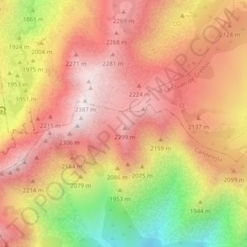
Name: Topografische Karte Navasomera, Höhe, Relief.

Ort: Navasomera, Candeleda, Ávila, Castilla y León, España (40.23918 -5.27242 40.25918 -5.25242)

Durchschnittliche Höhe: 2’033 m

Minimale Höhe: 1’470 m

Maximale Höhe: 2’381 m

Andere topografische Karten

Klicken Sie auf eine Karte, um ihre Topografie, ihre Höhe und ihr Relief anzuzeigen.

Sistema Central

España > Castilla y León > Candeleda

Sistema Central, Candeleda, Ávila, Castilla y León, España

Durchschnittliche Höhe: 2’191 m

Puerto de Candeleda

España > Castilla y León > Candeleda

Puerto de Candeleda, Candeleda, Ávila, Castilla y León, España

Durchschnittliche Höhe: 1’884 m

El Raso

España > Castilla y León > Candeleda

El Raso, Candeleda, Ávila, Castilla y León, 05489, España

Durchschnittliche Höhe: 555 m

Pico Almanzor

España > Castilla y León > Candeleda

Pico Almanzor, Candeleda, Ávila, Castilla y León, España

Durchschnittliche Höhe: 2’159 m