Geolokalisieren

Topografische Karte Northill

Klicken Sie auf die Karte, um die Höhe anzuzeigen.

👉 Easily get elevation data in JSON, GeoTIFF and KML formats using Elevation API
Vielen Dank für die Unterstützung dieser Website ❤️
Spenden

Rüste dich für dein nächstes Abenteuer:

Als Amazon-Partner verdient diese Seite an qualifizierten Käufen, ohne dass Ihnen zusätzliche Kosten entstehen.

Northill

Topographically, Northill stands on a slightly elevated ridge that runs north to south. The village lies on the border of the Bedfordshire and Cambridgeshire Claylands and the Bedfordshire Greensand Ridge; National Character Areas designated by Natural England. Central Bedfordshire Council has classified the local landscape around the village as within the Mid Greensand Ridge. The surrounding area is mostly arable farmland but there are significant areas of woodland to the west of the village, and parkland at Ickwell. The north and east of the parish form part of the predominantly flat, Lower Ivel Clay Valley.

Wikipedia (CC-BY-SA 3.0)

Über diese Karte

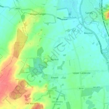
Name: Topografische Karte Northill, Höhe, Relief.

Ort: Northill, Central Bedfordshire, England, United Kingdom (52.08943 -0.35975 52.12687 -0.26882)

Durchschnittliche Höhe: 37 m

Minimale Höhe: 19 m

Maximale Höhe: 80 m

Andere topografische Karten

Klicken Sie auf eine Karte, um ihre Topografie, ihre Höhe und ihr Relief anzuzeigen.

Leighton Buzzard

United Kingdom > England > Central Bedfordshire

Durchschnittliche Höhe: 103 m

Greenfield

United Kingdom > England > Central Bedfordshire

Durchschnittliche Höhe: 72 m

Flitton

United Kingdom > England > Central Bedfordshire

Durchschnittliche Höhe: 70 m

Dunstable Downs

United Kingdom > England > Central Bedfordshire > Church End

Because of its elevation, Dunstable Downs hosted a station in the shutter telegraph chain which connected the Admiralty in London to its naval ships in the port of Great Yarmouth during the years 1808 to 1814.

Durchschnittliche Höhe: 178 m

Sharpenhoe

United Kingdom > England > Central Bedfordshire

Durchschnittliche Höhe: 93 m

Edgecote

United Kingdom > England > Central Bedfordshire > Caddington > Aley Green

Durchschnittliche Höhe: 168 m

Blow's Downs

United Kingdom > England > Central Bedfordshire > Dunstable

Durchschnittliche Höhe: 164 m

Lower Stondon

United Kingdom > England > Central Bedfordshire

Durchschnittliche Höhe: 57 m

Upper Caldecote

United Kingdom > England > Central Bedfordshire

Durchschnittliche Höhe: 31 m

Upper Sundon

United Kingdom > England > Central Bedfordshire

Durchschnittliche Höhe: 125 m

Wingfield

United Kingdom > England > Central Bedfordshire > Tebworth

Durchschnittliche Höhe: 118 m

Great Billington

United Kingdom > England > Central Bedfordshire

Durchschnittliche Höhe: 94 m

Chaul End

United Kingdom > England > Central Bedfordshire

Durchschnittliche Höhe: 159 m

Campton

United Kingdom > England > Central Bedfordshire

Durchschnittliche Höhe: 56 m

Salford

United Kingdom > England > Central Bedfordshire

Durchschnittliche Höhe: 82 m

Warden Hill

United Kingdom > England > Central Bedfordshire > Streatley

Durchschnittliche Höhe: 142 m

Dunton Fen

United Kingdom > England > Central Bedfordshire > Dunton

Durchschnittliche Höhe: 37 m

Ireland

United Kingdom > England > Central Bedfordshire

Durchschnittliche Höhe: 59 m

Linslade

United Kingdom > England > Central Bedfordshire

Durchschnittliche Höhe: 104 m

Lower Shelton

United Kingdom > England > Central Bedfordshire

Durchschnittliche Höhe: 50 m

Pegsdon Hills

United Kingdom > England > Central Bedfordshire > Offley

Durchschnittliche Höhe: 126 m

Church End

United Kingdom > England > Central Bedfordshire > Arlesey

Durchschnittliche Höhe: 45 m

Broom

United Kingdom > England > Central Bedfordshire

Durchschnittliche Höhe: 37 m

Pix Brook

United Kingdom > England > Central Bedfordshire > Stotfold

Durchschnittliche Höhe: 56 m

Clipstone

United Kingdom > England > Central Bedfordshire > Eggington

Durchschnittliche Höhe: 105 m

Stanford

United Kingdom > England > Central Bedfordshire > Stanford

Durchschnittliche Höhe: 42 m

Hatch

United Kingdom > England > Central Bedfordshire > Northill

Durchschnittliche Höhe: 30 m

Hoo Hill

United Kingdom > England > Central Bedfordshire > Clifton

Durchschnittliche Höhe: 50 m

Leighton Buzzard

United Kingdom > England > Central Bedfordshire

Durchschnittliche Höhe: 103 m

Leighton Buzzard

United Kingdom > England > Central Bedfordshire

Durchschnittliche Höhe: 103 m

Lower Stondon

United Kingdom > England > Central Bedfordshire

Durchschnittliche Höhe: 57 m

Broom

United Kingdom > England > Central Bedfordshire

Durchschnittliche Höhe: 37 m

Rüste dich für dein nächstes Abenteuer:

💧Outdoor Wasserfilter - Zuverlässige Filterlösungen für sauberes Trinkwasser unterwegs
🧣Multifunktionstücher - Vielseitige Tücher für Schutz vor Wind, Sonne und Kälte
🔥Campingkocher - Schnelle warme Mahlzeiten in der freien Natur
🦶Orthopädische Einlegesohlen - Zusätzlicher Support für lange Tage auf steinigem Untergrund
🐕Hunde-Wandergeschirre - Sicherer Halt für den vierbeinigen Begleiter

Als Amazon-Partner verdient diese Seite an qualifizierten Käufen, ohne dass Ihnen zusätzliche Kosten entstehen.