
Topografische Karte Croom
Interaktive Karte
Klicken Sie auf die Karte, um die Höhe anzuzeigen.
Über diese Karte
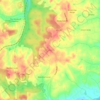
Name: Topografische Karte Croom, Höhe, Relief.
Ort: Croom, Prince George's County, Maryland, United States (38.73262 -76.78386 38.77262 -76.74386)
Durchschnittliche Höhe: 47 m
Minimale Höhe: 11 m
Maximale Höhe: 72 m
Andere topografische Karten
Klicken Sie auf eine Karte, um ihre Topografie, ihre Höhe und ihr Relief anzuzeigen.
Bradbury Park
United States > Maryland > Prince George's County > Suitland
Bradbury Park, Suitland, Prince George's County, Maryland, 20233, United States
Durchschnittliche Höhe: 80 m
East Riverdale
United States > Maryland > Prince George's County > East Riverdale
East Riverdale, Prince George's County, Maryland, 20737, United States
Durchschnittliche Höhe: 36 m
Queenland
United States > Maryland > Prince George's County > Rosaryville
Queenland, Rosaryville, Prince George's County, Maryland, 20772, United States
Durchschnittliche Höhe: 42 m
Washington, Baltimore & Annapolis Trail
United States > Maryland > Prince George's County > Bowie
Washington, Baltimore & Annapolis Trail, Bowie, Prince George's County, Maryland, United States
Durchschnittliche Höhe: 31 m
Potomac Vista
United States > Maryland > Prince George's County > National Harbor > Potomac Vista
Potomac Vista, National Harbor, Prince George's County, Maryland, 20745-3027, United States
Durchschnittliche Höhe: 26 m
Jackson Landing
United States > Maryland > Prince George's County > Jackson Landing
Jackson Landing, Prince George's County, Maryland, United States
Durchschnittliche Höhe: 15 m
Coles Corner
United States > Maryland > Prince George's County > Clinton
Coles Corner, Clinton, Prince George's County, Maryland, 20762, United States
Durchschnittliche Höhe: 73 m