Geolokalisieren

Topografische Karte West Perth

Klicken Sie auf die Karte, um die Höhe anzuzeigen.

Über diese Karte

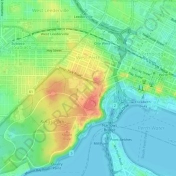
Name: Topografische Karte West Perth, Höhe, Relief.

Ort: West Perth, City of Perth, Western Australia, 6005, Australia (-31.97377 115.81787 -31.93644 115.85835)

Durchschnittliche Höhe: 26 m

Minimale Höhe: 0 m

Maximale Höhe: 81 m

Andere topografische Karten

Klicken Sie auf eine Karte, um ihre Topografie, ihre Höhe und ihr Relief anzuzeigen.

Kings Park

Australia > Western Australia > City of Perth > Perth

Durchschnittliche Höhe: 31 m

Langley Park

Australia > Western Australia > City of Perth > Perth

Durchschnittliche Höhe: 9 m

Russell Square

Australia > Western Australia > City of Perth > Perth

Durchschnittliche Höhe: 25 m

Acacia Garden

Australia > Western Australia > City of Perth > Perth

Durchschnittliche Höhe: 27 m

Perth

Australia > Western Australia > City of Perth

Perth, the capital of Western Australia, is situated on the Swan Coastal Plain, a flat expanse of sandy soil nestled between the Indian Ocean to the west and the Darling Scarp to the east. The Darling Scarp, also known as the Darling Range, is a low escarpment that extends north–south, marking a distinct…

Durchschnittliche Höhe: 26 m

Point Fraser

Australia > Western Australia > City of Perth

Durchschnittliche Höhe: 8 m

Perth

Australia > Western Australia > City of Perth

Durchschnittliche Höhe: 26 m

Perth

Australia > Western Australia > City of Perth

Perth, the capital of Western Australia, is situated on the Swan Coastal Plain, a flat expanse of sandy soil nestled between the Indian Ocean to the west and the Darling Scarp to the east. The Darling Scarp, also known as the Darling Range, is a low escarpment that extends north–south, marking a distinct…

Durchschnittliche Höhe: 26 m

Rüste dich für dein nächstes Abenteuer:

🔋Solar-Powerbanks - Unabhängige Stromversorgung für GPS und Smartphones im Gelände
📟LVS-Geräte - Essenzielle Sicherheitsausrüstung für den Winter
🧭Karten‑ & Kompass‑Sets - Kombipakete für klassische Navigation
🩺Outdoor Erste‑Hilfe‑Sets - Komplettsets für kleinere und größere Verletzungen unterwegs
🧤Outdoor‑Handschuhe - Schützende Handschuhe für Berg‑ und Kälteeinsätze

Als Amazon-Partner verdient diese Seite an qualifizierten Käufen, ohne dass Ihnen zusätzliche Kosten entstehen.