
Spenden
Rüste dich für dein nächstes Abenteuer:
Als Amazon-Partner verdient diese Seite an qualifizierten Käufen, ohne dass Ihnen zusätzliche Kosten entstehen.
Topografische Karte Lahaina
Klicken Sie auf die Karte, um die Höhe anzuzeigen.
Spenden
Rüste dich für dein nächstes Abenteuer:
Als Amazon-Partner verdient diese Seite an qualifizierten Käufen, ohne dass Ihnen zusätzliche Kosten entstehen.
Über diese Karte
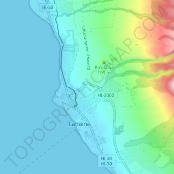
Name: Topografische Karte Lahaina, Höhe, Relief.
Ort: Lahaina, Maui County, Hawaii, United States (20.85558 -156.69490 20.91834 -156.65032)
Durchschnittliche Höhe: 101 m
Minimale Höhe: -2 m
Maximale Höhe: 623 m
Spenden
Rüste dich für dein nächstes Abenteuer:
Als Amazon-Partner verdient diese Seite an qualifizierten Käufen, ohne dass Ihnen zusätzliche Kosten entstehen.
Andere topografische Karten
Klicken Sie auf eine Karte, um ihre Topografie, ihre Höhe und ihr Relief anzuzeigen.
Kula
United States > Hawaii > Maui County
Kula is a district and census-designated place (CDP) of Maui, Hawaii, that stretches across the "up-country", the western-facing slopes of Haleakalā, from Makawao to Kanaio. Most of the residential areas lie between about 500 to 1,100 m (1,600 to 3,600 ft) in elevation. The district has traditionally been…
Durchschnittliche Höhe: 740 m
Spenden
Rüste dich für dein nächstes Abenteuer:
Als Amazon-Partner verdient diese Seite an qualifizierten Käufen, ohne dass Ihnen zusätzliche Kosten entstehen.
Spenden
Rüste dich für dein nächstes Abenteuer:
Als Amazon-Partner verdient diese Seite an qualifizierten Käufen, ohne dass Ihnen zusätzliche Kosten entstehen.
Haleakalā Observatories
United States > Hawaii > Maui County
The Haleakalā Observatory, also known as the Haleakalā High Altitude Observatory Site, is Hawaii's first astronomical research observatory. It is located on the island of Maui and is owned by the Institute for Astronomy of the University of Hawaiʻi, which operates some of the facilities on the site and…
Durchschnittliche Höhe: 2’811 m
Spenden
Rüste dich für dein nächstes Abenteuer:
Als Amazon-Partner verdient diese Seite an qualifizierten Käufen, ohne dass Ihnen zusätzliche Kosten entstehen.
Kula
United States > Hawaii > Maui County
Kula is a census-designated place (CDP) of Maui, Hawaii. It stretches across Upcountry Maui, the western-facing slopes of Haleakalā. Most residential areas lie between about 500 to 1,100 m (1,600 to 3,600 ft) in elevation. The district is distinct from the generally hotter and busier coastal areas. The…
Durchschnittliche Höhe: 740 m
Spenden
Rüste dich für dein nächstes Abenteuer:
Als Amazon-Partner verdient diese Seite an qualifizierten Käufen, ohne dass Ihnen zusätzliche Kosten entstehen.
Molokini Shoal Marine Life Conservation District
United States > Hawaii > Maui County
Durchschnittliche Höhe: 0 m
Spenden
Rüste dich für dein nächstes Abenteuer:
Als Amazon-Partner verdient diese Seite an qualifizierten Käufen, ohne dass Ihnen zusätzliche Kosten entstehen.
Spenden
Rüste dich für dein nächstes Abenteuer:
Als Amazon-Partner verdient diese Seite an qualifizierten Käufen, ohne dass Ihnen zusätzliche Kosten entstehen.