
Spenden
Rüste dich für dein nächstes Abenteuer:
Als Amazon-Partner verdient diese Seite an qualifizierten Käufen, ohne dass Ihnen zusätzliche Kosten entstehen.
Topografische Karte Little Easton
Klicken Sie auf die Karte, um die Höhe anzuzeigen.
Spenden
Rüste dich für dein nächstes Abenteuer:
Als Amazon-Partner verdient diese Seite an qualifizierten Käufen, ohne dass Ihnen zusätzliche Kosten entstehen.
Little Easton
Living in the parish were Lord and Lady Brooke, the later Earl and Countess of Warwick, at Easton Lodge, who were also resident at Berwick House in the Stable Yard of St James's Palace, London, and in 1902, after elevation to title, Warwick Castle. Parish occupations in 1882 included three farmers, one of whom was also a miller (water), a farm bailiff, a beer retailer, a fanwright (maker of fans), two shopkeepers, the publican of the Stag Inn, an accountant, an agent to the Earl of Rosslyn, and a clerk to the Easton estates. By 1902 the number of farmers and beer retailers remained the same. The Stag Inn was still operating, and there was a wheelwright, although now only one shopkeeper. There was a Treasurer and Honorary Secretary of the Workmen's Club, and the artists Frank and Charlotte Mura at Mill End studio. The clerk to the Easton estates remained, although the agent to the Earl of Rosslyn didn't.
Spenden
Rüste dich für dein nächstes Abenteuer:
Als Amazon-Partner verdient diese Seite an qualifizierten Käufen, ohne dass Ihnen zusätzliche Kosten entstehen.
Über diese Karte
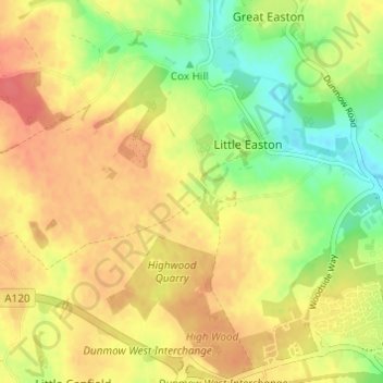
Name: Topografische Karte Little Easton, Höhe, Relief.
Ort: Little Easton, Uttlesford, Essex, England, United Kingdom (51.87375 0.29309 51.90178 0.35401)
Durchschnittliche Höhe: 88 m
Minimale Höhe: 56 m
Maximale Höhe: 112 m
Spenden
Rüste dich für dein nächstes Abenteuer:
Als Amazon-Partner verdient diese Seite an qualifizierten Käufen, ohne dass Ihnen zusätzliche Kosten entstehen.