
Topografische Karte Lake Bullen Merri
Interaktive Karte
Klicken Sie auf die Karte, um die Höhe anzuzeigen.
Über diese Karte
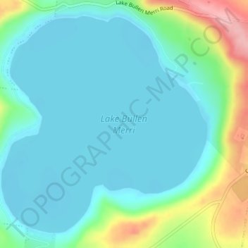
Name: Topografische Karte Lake Bullen Merri, Höhe, Relief.
Durchschnittliche Höhe: 171 m
Minimale Höhe: 139 m
Maximale Höhe: 281 m
The smaller lake to the north of Lake Bullen Merri has a maximum depth of 20 m (66 ft). The two lakes are linked by an overflow channel in the common wall at an elevation of 175 m. There is a 19th-century record of water from Bullen Merri overflowing into Gnotuk.
Andere topografische Karten
Klicken Sie auf eine Karte, um ihre Topografie, ihre Höhe und ihr Relief anzuzeigen.
Mount Sugarloaf
Australia > Victoria > Camperdown
Mount Sugarloaf, Camperdown, Shire of Corangamite, Victoria, 3260, Australia
Durchschnittliche Höhe: 201 m
Camperdown
Australia > Victoria > Camperdown
Camperdown, Shire of Corangamite, Barwon South West, Victoria, 3260, Australia
Durchschnittliche Höhe: 170 m