
Topografische Karte Portage
Interaktive Karte
Klicken Sie auf die Karte, um die Höhe anzuzeigen.
Über diese Karte
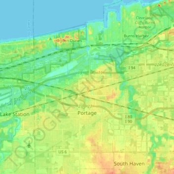
Name: Topografische Karte Portage, Höhe, Relief.
Ort: Portage, Porter County, Indiana, United States (41.53604 -87.22256 41.64899 -87.12452)
Durchschnittliche Höhe: 190 m
Minimale Höhe: 175 m
Maximale Höhe: 212 m
Andere topografische Karten
Klicken Sie auf eine Karte, um ihre Topografie, ihre Höhe und ihr Relief anzuzeigen.
Valparaiso
United States > Indiana > Porter County
Valparaiso, Porter County, Indiana, United States
Durchschnittliche Höhe: 235 m
Burns Harbor
United States > Indiana > Porter County
Burns Harbor, Porter County, Indiana, United States
Durchschnittliche Höhe: 189 m
Indiana Dunes National Park
United States > Indiana > Porter County > Portage
Indiana Dunes National Park, Portage, Porter County, Indiana, 46403, United States
Durchschnittliche Höhe: 188 m
Ogden Dunes
United States > Indiana > Porter County
Ogden Dunes, Porter County, Indiana, United States
Durchschnittliche Höhe: 184 m
Kouts
United States > Indiana > Porter County
Kouts, Porter County, Indiana, 46347, United States
Durchschnittliche Höhe: 208 m
Chesterton
United States > Indiana > Porter County
Chesterton, Porter County, Indiana, 46304, United States
Durchschnittliche Höhe: 200 m
Chesterton
United States > Indiana > Porter County > Chesterton
Chesterton, Porter County, Indiana, 46304, United States
Durchschnittliche Höhe: 197 m
Beverly Shores
United States > Indiana > Porter County > Beverly Shores > Beverly Shores
Beverly Shores, Porter County, Indiana, 46301, United States
Durchschnittliche Höhe: 182 m
Hebron
United States > Indiana > Porter County
Hebron, Porter County, Indiana, 46341, United States
Durchschnittliche Höhe: 213 m