
Spenden
Rüste dich für dein nächstes Abenteuer:
Als Amazon-Partner verdient diese Seite an qualifizierten Käufen, ohne dass Ihnen zusätzliche Kosten entstehen.
Topografische Karte North Pownal
Klicken Sie auf die Karte, um die Höhe anzuzeigen.
Spenden
Rüste dich für dein nächstes Abenteuer:
Als Amazon-Partner verdient diese Seite an qualifizierten Käufen, ohne dass Ihnen zusätzliche Kosten entstehen.
Über diese Karte
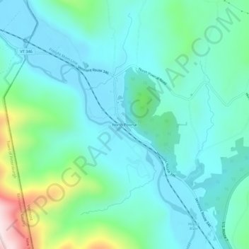
Name: Topografische Karte North Pownal, Höhe, Relief.
Durchschnittliche Höhe: 254 m
Minimale Höhe: 144 m
Maximale Höhe: 689 m
Spenden
Rüste dich für dein nächstes Abenteuer:
Als Amazon-Partner verdient diese Seite an qualifizierten Käufen, ohne dass Ihnen zusätzliche Kosten entstehen.
Andere topografische Karten
Klicken Sie auf eine Karte, um ihre Topografie, ihre Höhe und ihr Relief anzuzeigen.
North Bennington
United States > Vermont > Bennington County > Bennington
Durchschnittliche Höhe: 197 m
Peru
United States > Vermont > Bennington County
Peru is located in northeastern Bennington County, bordered by Rutland County to the north. The crest of the Green Mountains runs from north to the south through the western half of the town, traversed by the Long Trail/Appalachian Trail. 3,300-foot-high (1,000 m) Bromley Mountain and its ski area are in the…
Durchschnittliche Höhe: 595 m
Spenden
Rüste dich für dein nächstes Abenteuer:
Als Amazon-Partner verdient diese Seite an qualifizierten Käufen, ohne dass Ihnen zusätzliche Kosten entstehen.
Manchester
United States > Vermont > Bennington County
Manchester is located in north-central Bennington County, lying between the Green Mountains to the east and the Taconic Range to the west. Equinox Mountain, the highest summit in the Taconics, with an elevation of 3,850 feet (1,170 m), is in the western part of the town. Manchester is drained by the Batten…
Durchschnittliche Höhe: 453 m
Spenden
Rüste dich für dein nächstes Abenteuer:
Als Amazon-Partner verdient diese Seite an qualifizierten Käufen, ohne dass Ihnen zusätzliche Kosten entstehen.
South Shaftsbury
United States > Vermont > Bennington County > Shaftsbury
Durchschnittliche Höhe: 277 m
Spenden
Rüste dich für dein nächstes Abenteuer:
Als Amazon-Partner verdient diese Seite an qualifizierten Käufen, ohne dass Ihnen zusätzliche Kosten entstehen.
Peru
United States > Vermont > Bennington County
Peru is located in northeastern Bennington County, bordered by Rutland County to the north. The crest of the Green Mountains runs from north to the south through the western half of the town, traversed by the Long Trail/Appalachian Trail. 3,300-foot-high (1,000 m) Bromley Mountain and its ski area are in the…
Durchschnittliche Höhe: 595 m
Spenden
Rüste dich für dein nächstes Abenteuer:
Als Amazon-Partner verdient diese Seite an qualifizierten Käufen, ohne dass Ihnen zusätzliche Kosten entstehen.
North Bennington
United States > Vermont > Bennington County > Bennington
Durchschnittliche Höhe: 197 m
Spenden
Rüste dich für dein nächstes Abenteuer:
Als Amazon-Partner verdient diese Seite an qualifizierten Käufen, ohne dass Ihnen zusätzliche Kosten entstehen.
Manchester
United States > Vermont > Bennington County
Manchester is located in north-central Bennington County, lying between the Green Mountains to the east and the Taconic Range to the west. Equinox Mountain, the highest summit in the Taconics, with an elevation of 3,850 feet (1,170 m), is in the western part of the town. Manchester is drained by the Batten…
Durchschnittliche Höhe: 453 m