Geolokalisieren

Topografische Karte Taghmon

Klicken Sie auf die Karte, um die Höhe anzuzeigen.

Taghmon

Many Irish place names are topographically descriptive, and 'Achadh Liathdrom' is no exception. From the western side of the Forth Mountain, as it slopes down towards Ballintlea, a succession of gradual hills and valleys undulate their way across this part of County Wexford towards Camross, Bree and Carrigbyrne Hills. It is on one of these hills or ridges that the village of Taghmon is situated.

Wikipedia (CC-BY-SA 3.0)

Über diese Karte

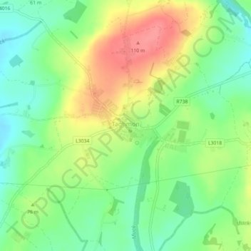
Name: Topografische Karte Taghmon, Höhe, Relief.

Ort: Taghmon, Taghmon ED, New Ross Municipal District, County Wexford, Leinster, Ireland (52.31847 -6.66692 52.32679 -6.64404)

Durchschnittliche Höhe: 67 m

Minimale Höhe: 35 m

Maximale Höhe: 108 m

Andere topografische Karten

Klicken Sie auf eine Karte, um ihre Topografie, ihre Höhe und ihr Relief anzuzeigen.

Rathnure

Ireland > County Wexford > New Ross Municipal District

Durchschnittliche Höhe: 118 m

Gusserane

Ireland > County Wexford > New Ross Municipal District

Durchschnittliche Höhe: 51 m

Raheen

Ireland > County Wexford > New Ross Municipal District

Durchschnittliche Höhe: 86 m

Gusserane

Ireland > County Wexford > New Ross Municipal District

Durchschnittliche Höhe: 51 m

Rüste dich für dein nächstes Abenteuer:

👟Approach‑Schuhe - Vielseitige Schuhe für Zustiege und leichte Kletterpassagen
🧼Biologische Outdoor-Seife - Umweltfreundliche Hygiene in der Natur
🗺️Wanderkarten Schweiz - Topografische und detaillierte Wanderkarten für alle Regionen der Schweiz
Sportuhren mit Barometer - Höhenmessung und Wettertrend direkt am Handgelenk
📡GPS‑Handgeräte - Outdoor‑GPS‑Geräte zur Wegnavigation und Tracking

Als Amazon-Partner verdient diese Seite an qualifizierten Käufen, ohne dass Ihnen zusätzliche Kosten entstehen.