
Topografische Karte A Baña
Interaktive Karte
Klicken Sie auf die Karte, um die Höhe anzuzeigen.
Über diese Karte
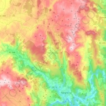
Name: Topografische Karte A Baña, Höhe, Relief.
Ort: A Baña, A Barcala, A Coruña, Galicia, 15863, Spain (42.91627 -8.84152 43.00686 -8.65624)
Durchschnittliche Höhe: 325 m
Minimale Höhe: 128 m
Maximale Höhe: 516 m
Vesía is a town situated near the centre of the A Baña municipality, in the A Coruña province. It is part of the parish of San Vicente, the capital of the municipality. Vesía is at an altitude of 317.6 meters above sea level, and stands at an incline of 20.89%. Vesía has a population of around 40 people, the majority of whom are between 65 and 80 years old as the area has suffered youth emigration.
Andere topografische Karten
Klicken Sie auf eine Karte, um ihre Topografie, ihre Höhe und ihr Relief anzuzeigen.