
Topografische Karte Adana
Interaktive Karte
Klicken Sie auf die Karte, um die Höhe anzuzeigen.
Über diese Karte
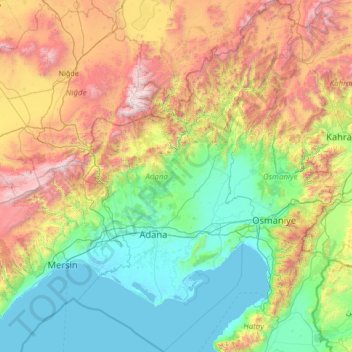
Name: Topografische Karte Adana, Höhe, Relief.
Ort: Adana, Mediterranean Region, Turkey (36.26304 34.73930 38.40460 36.40958)
Durchschnittliche Höhe: 879 m
Minimale Höhe: -2 m
Maximale Höhe: 3’603 m
Aladağlar National Park, located north of Adana, is a huge park of around 55,000 hectares, the summit of Demirkazik at 3756m is the highest point in the middle Taurus mountain range. There is a huge range of flora and fauna, and visitors may fish in the streams full of trout. Wildlife includes wild goats, bears, lynx and sable. The most common species of plant life is black pine and cluster pine trees, with some cedar dotted between, and fir trees in the northern areas with higher humidity. The Alpine region, from the upper borders of the forest, has pastures with rocky areas and little variety of plant life because of the high altitude and slope.
Andere topografische Karten
Klicken Sie auf eine Karte, um ihre Topografie, ihre Höhe und ihr Relief anzuzeigen.
Karacaşehir
Karacaşehir, Odunpazarı, Eskişehir, Central Anatolia Region, 26160, Turkey
Durchschnittliche Höhe: 883 m
Paşabahçe Mahallesi
Paşabahçe Mahallesi, Beykoz, Istanbul, Marmara Region, Turkey
Durchschnittliche Höhe: 38 m
Balaban Mahallesi
Balaban Mahallesi, Arnavutköy, Istanbul, Marmara Region, Turkey
Durchschnittliche Höhe: 13 m
Bostankaya
Bostankaya, Ulaş, Sivas, Central Anatolia Region, Turkey
Durchschnittliche Höhe: 1’376 m
Ankara Kalesi
Ankara Kalesi, Kağnı Sokak, Kale Mahallesi, Altındağ, Ankara, Central Anatolia Region, 06250, Turkey
Durchschnittliche Höhe: 890 m
Salur
Salur, Çorum Merkez, Çorum, Black Sea Region, Turkey
Durchschnittliche Höhe: 599 m
Kuzköy Mahallesi
Kuzköy Mahallesi, Kabataş, Ordu, Black Sea Region, Turkey
Durchschnittliche Höhe: 811 m
Yozgat
Yozgat, Yozgat Merkez, Yozgat, Central Anatolia Region, 66100, Turkey
Durchschnittliche Höhe: 1’250 m
Bademli Mahallesi
Bademli Mahallesi, Ödemiş, Izmir, Aegean Region, Turkey
Durchschnittliche Höhe: 686 m
Bahçelievler Mahallesi
Bahçelievler Mahallesi, Kars Merkez, Kars, Eastern Anatolia Region, Turkey
Durchschnittliche Höhe: 1’769 m
Oğlakçı
Oğlakçı, Sivrihisar, Eskişehir, Central Anatolia Region, Turkey
Durchschnittliche Höhe: 873 m
Merkez Dağı
Merkez Dağı, Başkale, Van, Eastern Anatolia Region, Turkey
Durchschnittliche Höhe: 2’994 m
Yunusemre Mahallesi
Yunusemre Mahallesi, Sivas Belediyesi, Sivas Merkez, Sivas, Central Anatolia Region, Turkey
Durchschnittliche Höhe: 1’329 m
Yalıköy Mahallesi
Yalıköy Mahallesi, Beykoz, Istanbul, Marmara Region, Turkey
Durchschnittliche Höhe: 31 m
Göksu Mahallesi
Göksu Mahallesi, Beykoz, Istanbul, Marmara Region, Turkey
Durchschnittliche Höhe: 48 m
Çayırova Mahallesi
Çayırova Mahallesi, Çayırova, Kocaeli Province, Marmara Region, 41420, Turkey
Durchschnittliche Höhe: 50 m
Viaport Theme Park
Viaport Theme Park, Yenişehir Mahallesi, Pendik, Istanbul, Marmara Region, 34912, Turkey
Durchschnittliche Höhe: 126 m
Millet Mahallesi
Millet Mahallesi, Izmir, Konak, Aegean Region, Turkey
Durchschnittliche Höhe: 132 m
Fulya Mahallesi
Fulya Mahallesi, Şişli, Istanbul, Marmara Region, 34346, Turkey
Durchschnittliche Höhe: 98 m
Kayalar Mahallesi
Turkey > Denizli > Merkezefendi
Kayalar Mahallesi, Denizli, Merkezefendi, Denizli, Aegean Region, Turkey
Durchschnittliche Höhe: 373 m