
Topografische Karte Christmas Island
Interaktive Karte
Klicken Sie auf die Karte, um die Höhe anzuzeigen.
Über diese Karte
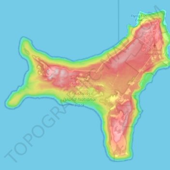
Name: Topografische Karte Christmas Island, Höhe, Relief.
Durchschnittliche Höhe: 69 m
Minimale Höhe: 0 m
Maximale Höhe: 363 m
Steep cliffs along much of the coast rise abruptly to a central plateau. Elevation ranges from sea level to 361 m (1,184 ft) at Murray Hill. The island is mainly tropical rainforest, 63% of which is national parkland. The narrow fringing reef surrounding the island poses a maritime hazard.