
Spenden
Rüste dich für dein nächstes Abenteuer:
Als Amazon-Partner verdient diese Seite an qualifizierten Käufen, ohne dass Ihnen zusätzliche Kosten entstehen.
Topografische Karte Capulin
Klicken Sie auf die Karte, um die Höhe anzuzeigen.
Spenden
Rüste dich für dein nächstes Abenteuer:
Als Amazon-Partner verdient diese Seite an qualifizierten Käufen, ohne dass Ihnen zusätzliche Kosten entstehen.
Über diese Karte
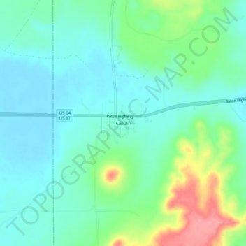
Name: Topografische Karte Capulin, Höhe, Relief.
Ort: Capulin, Union County, New Mexico, 88414, United States (36.72108 -104.01361 36.76108 -103.97361)
Durchschnittliche Höhe: 2’098 m
Minimale Höhe: 2’069 m
Maximale Höhe: 2’181 m
Spenden
Rüste dich für dein nächstes Abenteuer:
Als Amazon-Partner verdient diese Seite an qualifizierten Käufen, ohne dass Ihnen zusätzliche Kosten entstehen.
Andere topografische Karten
Klicken Sie auf eine Karte, um ihre Topografie, ihre Höhe und ihr Relief anzuzeigen.
Clayton
United States > New Mexico > Union County
According to the United States Census Bureau, the town has a total area of 4.7 square miles (12 km2), all land. Clayton has an elevation of approximately 5,050 feet (1,540 m) above sea level. It is located about 130 miles (210 km) northwest of Amarillo, Texas. Clayton is considered to be in the Plains region…
Durchschnittliche Höhe: 1’526 m
Clayton Lake State Park and Dinosaur Trackways
United States > New Mexico > Union County
Durchschnittliche Höhe: 1’606 m
Clayton
United States > New Mexico > Union County
According to the United States Census Bureau, the town has a total area of 4.7 square miles (12 km2), all land. Clayton has an elevation of approximately 5,050 feet (1,540 m) above sea level. It is located about 130 miles (210 km) northwest of Amarillo, Texas. Clayton is considered to be in the Plains region…
Durchschnittliche Höhe: 1’526 m