
Topografische Karte Candon
Interaktive Karte
Klicken Sie auf die Karte, um die Höhe anzuzeigen.
Über diese Karte
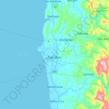
Name: Topografische Karte Candon, Höhe, Relief.
Ort: Candon, Ilocos Sur, Ilocos Region, 2710, Philippines (17.14484 120.40384 17.23809 120.54281)
Durchschnittliche Höhe: 30 m
Minimale Höhe: -1 m
Maximale Höhe: 249 m
Candon City is situated in the lower central portion of the Province of Ilocos Sur. It has a "C" shape with elevations ranging from 10 – 500 ft above sea level. The city is 346 kilometres (215 mi) from Metro Manila and 61 kilometres (38 mi) from Vigan City, the provincial capital.