
Topografische Karte Amman
Interaktive Karte
Klicken Sie auf die Karte, um die Höhe anzuzeigen.
Über diese Karte
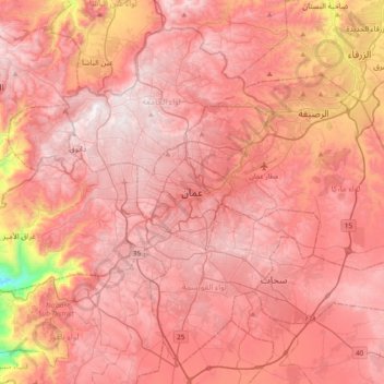
Name: Topografische Karte Amman, Höhe, Relief.
Durchschnittliche Höhe: 800 m
Minimale Höhe: 91 m
Maximale Höhe: 1’097 m
Amman is situated on the East Bank Plateau, an upland characterized by three major wadis which run through it. Originally, the city had been built on seven hills. Amman's terrain is typified by its mountains. The most important areas in the city are named after the hills or mountains they lie on. The area's elevation ranges from 1,000 to 1,100 m (3,300 to 3,600 ft). Al-Salt and al-Zarqa are located to the northwest and northeast, respectively, Madaba is located to the west, and al-Karak and Ma'an are to Amman's southwest and southeast, respectively. One of the only remaining springs in Amman now supplies the Zarqa River with water.
Andere topografische Karten
Klicken Sie auf eine Karte, um ihre Topografie, ihre Höhe und ihr Relief anzuzeigen.
Housing Bank Garden
Jordan > Amman > Amman Sub-District > Amman
Housing Bank Garden, Southern Abdoun, Amman, Amman Sub-District, Amman Qasabah District, Amman, Jordan
Durchschnittliche Höhe: 898 m
Abdoun
Jordan > Amman > Amman Sub-District > Amman
Abdoun, منطقة زهران, Amman, Amman Sub-District, Amman Qasabah District, Amman, 11181, Jordan
Durchschnittliche Höhe: 896 m