
Spenden
Rüste dich für dein nächstes Abenteuer:
Als Amazon-Partner verdient diese Seite an qualifizierten Käufen, ohne dass Ihnen zusätzliche Kosten entstehen.
Topografische Karte Bristol
Klicken Sie auf die Karte, um die Höhe anzuzeigen.
Spenden
Rüste dich für dein nächstes Abenteuer:
Als Amazon-Partner verdient diese Seite an qualifizierten Käufen, ohne dass Ihnen zusätzliche Kosten entstehen.
Bristol
Like much of the rest of the state, Bristol has a humid subtropical climate (Köppen climate classification: Cfa), although with significantly cooler temperatures, especially in the summer, due to elevation; it is part of USDA hardiness zone 6b, with areas to the southwest falling in zone 7a. The normal monthly mean temperature ranges from 35.2 °F (1.8 °C) in January to 74.6 °F (23.7 °C) in July, while, on average, 8.8 days have temperatures at or below freezing and 17 days with highs at or above 90 °F (32 °C) per year. The all-time record low is −21 °F (−29 °C), set on January 21, 1985, while the all-time record high is 103 °F (39 °C), set on June 30, 2012.
Spenden
Rüste dich für dein nächstes Abenteuer:
Als Amazon-Partner verdient diese Seite an qualifizierten Käufen, ohne dass Ihnen zusätzliche Kosten entstehen.
Über diese Karte
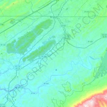
Name: Topografische Karte Bristol, Höhe, Relief.
Durchschnittliche Höhe: 543 m
Minimale Höhe: 417 m
Maximale Höhe: 1’282 m
Spenden
Rüste dich für dein nächstes Abenteuer:
Als Amazon-Partner verdient diese Seite an qualifizierten Käufen, ohne dass Ihnen zusätzliche Kosten entstehen.
Andere topografische Karten
Klicken Sie auf eine Karte, um ihre Topografie, ihre Höhe und ihr Relief anzuzeigen.
Spenden
Rüste dich für dein nächstes Abenteuer:
Als Amazon-Partner verdient diese Seite an qualifizierten Käufen, ohne dass Ihnen zusätzliche Kosten entstehen.
Spenden
Rüste dich für dein nächstes Abenteuer:
Als Amazon-Partner verdient diese Seite an qualifizierten Käufen, ohne dass Ihnen zusätzliche Kosten entstehen.
Bristol
United States > Tennessee > Sullivan County > Bristol > Bristol
Like much of the rest of the state, Bristol has a humid subtropical climate (Köppen climate classification: Cfa), although with significantly cooler temperatures, especially in the summer, due to elevation; it is part of USDA hardiness zone 6b, with areas to the southwest falling in zone 7a. The normal…
Durchschnittliche Höhe: 579 m
Spenden
Rüste dich für dein nächstes Abenteuer:
Als Amazon-Partner verdient diese Seite an qualifizierten Käufen, ohne dass Ihnen zusätzliche Kosten entstehen.
Midfields
United States > Tennessee > Sullivan County > Kingsport > Midfields
Durchschnittliche Höhe: 423 m
Bloomington Heights
United States > Tennessee > Sullivan County > Kingsport
Durchschnittliche Höhe: 409 m
Spenden
Rüste dich für dein nächstes Abenteuer:
Als Amazon-Partner verdient diese Seite an qualifizierten Käufen, ohne dass Ihnen zusätzliche Kosten entstehen.