
Topografische Karte Cement Hill
Interaktive Karte
Klicken Sie auf die Karte, um die Höhe anzuzeigen.
Über diese Karte
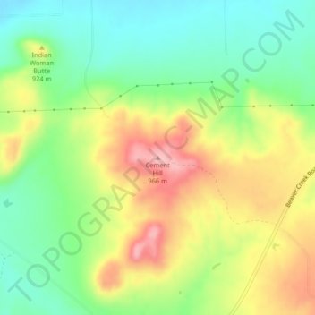
Name: Topografische Karte Cement Hill, Höhe, Relief.
Ort: Cement Hill, Hill County, Montana, United States (48.49439 -109.71247 48.49449 -109.71237)
Durchschnittliche Höhe: 882 m
Minimale Höhe: 817 m
Maximale Höhe: 968 m
Andere topografische Karten
Klicken Sie auf eine Karte, um ihre Topografie, ihre Höhe und ihr Relief anzuzeigen.
Rocky Boy's Agency
United States > Montana > Hill County > Rocky Boy's Agency
Rocky Boy's Agency, Hill County, Montana, United States
Durchschnittliche Höhe: 1’198 m
Havre
United States > Montana > Hill County > Havre
Havre, Hill County, Montana, 59501, United States
Durchschnittliche Höhe: 849 m
Havre
United States > Montana > Hill County
Havre, Hill County, Montana, United States
Durchschnittliche Höhe: 789 m