
Topografische Karte Ulah
Interaktive Karte
Klicken Sie auf die Karte, um die Höhe anzuzeigen.
Über diese Karte
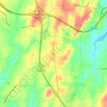
Name: Topografische Karte Ulah, Höhe, Relief.
Ort: Ulah, Randolph County, North Carolina, 27205, United States (35.61541 -79.84670 35.65541 -79.80670)
Durchschnittliche Höhe: 237 m
Minimale Höhe: 201 m
Maximale Höhe: 271 m
Andere topografische Karten
Klicken Sie auf eine Karte, um ihre Topografie, ihre Höhe und ihr Relief anzuzeigen.
Franklinville
United States > North Carolina > Randolph County
Franklinville, Randolph County, North Carolina, United States
Durchschnittliche Höhe: 163 m
Asheboro
United States > North Carolina > Randolph County
Asheboro, Randolph County, North Carolina, United States
Durchschnittliche Höhe: 208 m
Redding Hills
United States > North Carolina > Randolph County > Asheboro > Redding Hills
Redding Hills, Asheboro, Randolph County, North Carolina, 27203, United States
Durchschnittliche Höhe: 223 m