
Spenden
Rüste dich für dein nächstes Abenteuer:
Als Amazon-Partner verdient diese Seite an qualifizierten Käufen, ohne dass Ihnen zusätzliche Kosten entstehen.
Topografische Karte Schroeder Township
Klicken Sie auf die Karte, um die Höhe anzuzeigen.
Spenden
Rüste dich für dein nächstes Abenteuer:
Als Amazon-Partner verdient diese Seite an qualifizierten Käufen, ohne dass Ihnen zusätzliche Kosten entstehen.
Über diese Karte
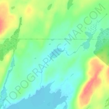
Name: Topografische Karte Schroeder Township, Höhe, Relief.
Durchschnittliche Höhe: 564 m
Minimale Höhe: 540 m
Maximale Höhe: 608 m
Spenden
Rüste dich für dein nächstes Abenteuer:
Als Amazon-Partner verdient diese Seite an qualifizierten Käufen, ohne dass Ihnen zusätzliche Kosten entstehen.
Andere topografische Karten
Klicken Sie auf eine Karte, um ihre Topografie, ihre Höhe und ihr Relief anzuzeigen.
Spenden
Rüste dich für dein nächstes Abenteuer:
Als Amazon-Partner verdient diese Seite an qualifizierten Käufen, ohne dass Ihnen zusätzliche Kosten entstehen.
Pigeon River
United States > Minnesota > Cook County
The Pigeon River originates from a chain of lakes along the US-Canada border, the highest of which, and furthest west, is Mountain Lake. Among the Pigeon's tributaries is the Arrow River of Ontario, which rises in South Lake, west of and at a lower elevation than Mountain Lake. South Lake is separated only by…
Durchschnittliche Höhe: 390 m
Spenden
Rüste dich für dein nächstes Abenteuer:
Als Amazon-Partner verdient diese Seite an qualifizierten Käufen, ohne dass Ihnen zusätzliche Kosten entstehen.
Eagle Mountain
United States > Minnesota > Cook County > West Cook
Eagle Mountain is only about 12 miles (19 km) from Minnesota's lowest elevation, Lake Superior, at 600 feet (183 m). It is part of the Canadian Shield. There is also another much shorter peak also named Eagle Mountain in northern Minnesota. The shorter peak is part of the Lutsen Mountains ski resort.
Durchschnittliche Höhe: 596 m
Brule Lake
United States > Minnesota > Cook County > West Cook
Brule Lake lies in a region which has seen human population since the end of the last ice age. It has variously been within the territory of the Dakota, Cree, Ojibwa, French, British, and Americans. It saw little development until the opening of a railroad that allowed loggers easier access to the interior of…
Durchschnittliche Höhe: 579 m
Eagle Mountain
United States > Minnesota > Cook County
Eagle Mountain is only about 15 miles (24 km) from Minnesota's lowest elevation, Lake Superior, at 600 feet (183 m). It is part of the Canadian Shield. Confusingly, there is another much shorter peak also named Eagle Mountain in northern Minnesota. The shorter peak is part of the Lutsen Mountains ski resort.
Durchschnittliche Höhe: 596 m
Spenden
Rüste dich für dein nächstes Abenteuer:
Als Amazon-Partner verdient diese Seite an qualifizierten Käufen, ohne dass Ihnen zusätzliche Kosten entstehen.