
Topografische Karte Baxter
Interaktive Karte
Klicken Sie auf die Karte, um die Höhe anzuzeigen.
Über diese Karte
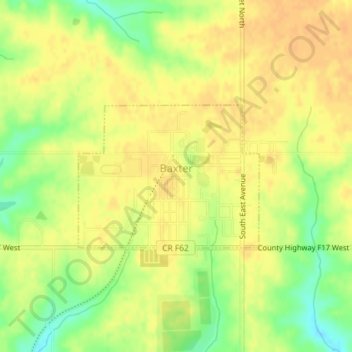
Name: Topografische Karte Baxter, Höhe, Relief.
Ort: Baxter, Jasper County, Iowa, United States (41.81999 -93.16168 41.83096 -93.14306)
Durchschnittliche Höhe: 302 m
Minimale Höhe: 280 m
Maximale Höhe: 312 m
Andere topografische Karten
Klicken Sie auf eine Karte, um ihre Topografie, ihre Höhe und ihr Relief anzuzeigen.
Newton
United States > Iowa > Jasper County
Newton, Jasper County, Iowa, 50208, United States
Durchschnittliche Höhe: 277 m
Galesburg
United States > Iowa > Jasper County
Galesburg, Jasper County, Iowa, 50232, United States
Durchschnittliche Höhe: 256 m
Colfax
United States > Iowa > Jasper County
Colfax, Jasper County, Iowa, 50054, United States
Durchschnittliche Höhe: 256 m
Monroe
United States > Iowa > Jasper County
Monroe, Jasper County, Iowa, United States
Durchschnittliche Höhe: 273 m
Kellogg
United States > Iowa > Jasper County > Kellogg > Kellogg
Kellogg, Jasper County, Iowa, 50135, United States
Durchschnittliche Höhe: 270 m
Kellogg
United States > Iowa > Jasper County
Kellogg, Jasper County, Iowa, United States
Durchschnittliche Höhe: 266 m
Prairie City
United States > Iowa > Jasper County
Prairie City, Jasper County, Iowa, United States
Durchschnittliche Höhe: 278 m