
Spenden
Rüste dich für dein nächstes Abenteuer:
Als Amazon-Partner verdient diese Seite an qualifizierten Käufen, ohne dass Ihnen zusätzliche Kosten entstehen.
Topografische Karte Tombstone
Klicken Sie auf die Karte, um die Höhe anzuzeigen.
Spenden
Rüste dich für dein nächstes Abenteuer:
Als Amazon-Partner verdient diese Seite an qualifizierten Käufen, ohne dass Ihnen zusätzliche Kosten entstehen.
Tombstone
The Tombstone District located at 31°42′57″N 110°3′53″W / 31.71583°N 110.06472°W / 31.71583; -110.06472 (31.715940, −110.064827) sits atop a mesa (elevation 4,539 feet [1,383 m]) in the San Pedro River valley between the Huachuca Mountains and Whetstone Mountains to the west, and the Mules and the Dragoon Mountains to the east. According to the United States Census Bureau, the city has a total area of 4.3 square miles (11.2 km2), all land.
Spenden
Rüste dich für dein nächstes Abenteuer:
Als Amazon-Partner verdient diese Seite an qualifizierten Käufen, ohne dass Ihnen zusätzliche Kosten entstehen.
Über diese Karte
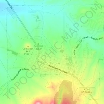
Name: Topografische Karte Tombstone, Höhe, Relief.
Ort: Tombstone, Cochise County, Arizona, 85638, United States (31.70272 -110.08222 31.73268 -110.04366)
Durchschnittliche Höhe: 1’364 m
Minimale Höhe: 1’307 m
Maximale Höhe: 1’468 m
Spenden
Rüste dich für dein nächstes Abenteuer:
Als Amazon-Partner verdient diese Seite an qualifizierten Käufen, ohne dass Ihnen zusätzliche Kosten entstehen.
Andere topografische Karten
Klicken Sie auf eine Karte, um ihre Topografie, ihre Höhe und ihr Relief anzuzeigen.
Willcox
United States > Arizona > Cochise County
Willcox's high elevation gives it a milder climate than the nearby Valley of the Sun and Sonoran Desert. It also receives more rainfall than Tucson and Phoenix due to the summer monsoon rains and thus it has a hot semi-arid climate (Koppen: BSh)
Durchschnittliche Höhe: 1’274 m
Spenden
Rüste dich für dein nächstes Abenteuer:
Als Amazon-Partner verdient diese Seite an qualifizierten Käufen, ohne dass Ihnen zusätzliche Kosten entstehen.
Sierra Vista Estates
United States > Arizona > Cochise County > Sierra Vista
Durchschnittliche Höhe: 1’429 m
Spenden
Rüste dich für dein nächstes Abenteuer:
Als Amazon-Partner verdient diese Seite an qualifizierten Käufen, ohne dass Ihnen zusätzliche Kosten entstehen.
Willcox
United States > Arizona > Cochise County
Willcox's high elevation gives it a milder climate than the nearby Valley of the Sun and Sonoran Desert. It also receives more rainfall than Tucson and Phoenix due to the summer monsoon rains and thus it has a hot semi-arid climate (Koppen: BSh).
Durchschnittliche Höhe: 1’274 m
Spenden
Rüste dich für dein nächstes Abenteuer:
Als Amazon-Partner verdient diese Seite an qualifizierten Käufen, ohne dass Ihnen zusätzliche Kosten entstehen.
Bakerville
United States > Arizona > Cochise County > Bisbee > Warren
Bakerville is a populated place situated within the city of Bisbee in Cochise County, Arizona, United States. It has an estimated elevation of 5,039 feet (1,536 m) above sea level.
Durchschnittliche Höhe: 1’579 m