
Topografische Karte Tallahassee
Klicken Sie auf die Karte, um die Höhe anzuzeigen.
Tallahassee
Tallahassee features a distinctive topography that is characterized by hilly terrain, which is somewhat atypical for the generally flat landscape of the state. The city is located at the southern end of the Red Hills Region and just above the Cody Scarp, with elevations ranging from about 7 feet near its low points to over 200 feet at its highest hills, including the area around the state capitol, which stands at approximately 203 feet above sea level. The city's landscape includes notable geographic features such as large lake basins, specifically Lake Jackson and Lake Lafayette, alongside the northern borders of the Apalachicola National Forest. This diverse terrain contributes to the region's unique ecological systems and provides various recreational opportunities.
Über diese Karte
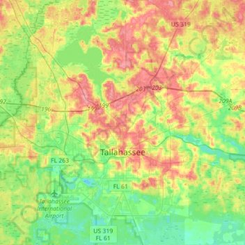
Name: Topografische Karte Tallahassee, Höhe, Relief.
Ort: Tallahassee, Leon County, Florida, United States (30.34670 -84.37804 30.58724 -84.12995)
Durchschnittliche Höhe: 36 m
Minimale Höhe: 2 m
Maximale Höhe: 81 m
Andere topografische Karten
Klicken Sie auf eine Karte, um ihre Topografie, ihre Höhe und ihr Relief anzuzeigen.
Miccosukee
United States > Florida > Leon County
By 1858, perhaps 200 ancestors of the modern Miccosukee and Seminole Tribes remained in Florida. They survived by moving into central and southern Florida to take advantage of the topography of Big Cypress and the Everglades, which was largely unknown to the remainder of the U.S. The American Civil War during…
Durchschnittliche Höhe: 59 m
Lake Jackson
United States > Florida > Leon County
The lake is located in the Red Hills Region, and has fluctuated from periods of being dry to a maximum elevation of 96 feet (29 m) above sea level. The lake is approximately 7.5 miles (12 km) long and its area is 6.2 square miles (16 km2). There is no outflow from streams or runoff.
Durchschnittliche Höhe: 45 m
Lake Ella
United States > Florida > Leon County > Tallahassee
In 1986, Lake Ella underwent extensive rehabilitation including sediment removal, reshaping of the shoreline, reducing the number of stormwater inflow pipes, and installation of an automatic alum treatment system. Lake Ella receives stormwater runoff from an urban watershed that is approximately 157 acres…
Durchschnittliche Höhe: 56 m
Fred O. Drake Park at Lake Ella
United States > Florida > Leon County > Tallahassee
Durchschnittliche Höhe: 56 m