
Topografische Karte Majare Hol
Interaktive Karte
Klicken Sie auf die Karte, um die Höhe anzuzeigen.
Über diese Karte
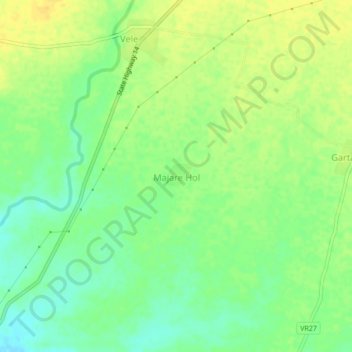
Name: Topografische Karte Majare Hol, Höhe, Relief.
Ort: Majare Hol, Chopda, Jalgaon, Maharashtra, 425107, India (21.18030 75.25564 21.22030 75.29564)
Durchschnittliche Höhe: 179 m
Minimale Höhe: 165 m
Maximale Höhe: 190 m
Andere topografische Karten
Klicken Sie auf eine Karte, um ihre Topografie, ihre Höhe und ihr Relief anzuzeigen.
Gul
India > Maharashtra > Chopda > Ambade
Gul, Ambade, Chopda, Jalgaon, Maharashtra, India
Durchschnittliche Höhe: 214 m
Adavad
India > Maharashtra > Chopda
Adavad, Chopda, Jalgaon, Maharashtra, 425303, India
Durchschnittliche Höhe: 195 m
Chahardi
India > Maharashtra > Chopda
Chahardi, Chopda, Jalgaon, Maharashtra, 425107, India
Durchschnittliche Höhe: 182 m