
Spenden
Rüste dich für dein nächstes Abenteuer:
Als Amazon-Partner verdient diese Seite an qualifizierten Käufen, ohne dass Ihnen zusätzliche Kosten entstehen.
Topografische Karte Upper Saucon
Klicken Sie auf die Karte, um die Höhe anzuzeigen.
Spenden
Rüste dich für dein nächstes Abenteuer:
Als Amazon-Partner verdient diese Seite an qualifizierten Käufen, ohne dass Ihnen zusätzliche Kosten entstehen.
Upper Saucon
According to the U.S. Census Bureau, the township has a total area of 24.6 square miles (63.7 km2), of which 24.5 square miles (63.4 km2) are land and 0.2 square miles (0.4 km2), or 0.59%, are water. Its boundary with Salisbury Township is located on South Mountain. Elevations range from 340 feet (100 m) in Spring Valley to 1,042 feet (318 m) at Bauer Rock atop South Mountain in Big Rock County Park. Upper Saucon is in the Delaware River watershed and is drained by Saucon Creek into the Lehigh River, except for a very small area in the extreme south just southwest of Locust Valley, which is drained by Unami Creek into Perkiomen Creek and the Schuylkill River.
Spenden
Rüste dich für dein nächstes Abenteuer:
Als Amazon-Partner verdient diese Seite an qualifizierten Käufen, ohne dass Ihnen zusätzliche Kosten entstehen.
Über diese Karte
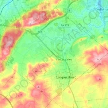
Name: Topografische Karte Upper Saucon, Höhe, Relief.
Ort: Upper Saucon, Lehigh County, Pennsylvania, United States (40.48798 -75.47584 40.58115 -75.33305)
Durchschnittliche Höhe: 175 m
Minimale Höhe: 77 m
Maximale Höhe: 316 m
Spenden
Rüste dich für dein nächstes Abenteuer:
Als Amazon-Partner verdient diese Seite an qualifizierten Käufen, ohne dass Ihnen zusätzliche Kosten entstehen.
Andere topografische Karten
Klicken Sie auf eine Karte, um ihre Topografie, ihre Höhe und ihr Relief anzuzeigen.
East Texas
United States > Pennsylvania > Lehigh County > Lower Macungie Township
Durchschnittliche Höhe: 126 m
Fogelsville
United States > Pennsylvania > Lehigh County > Upper Macungie Township
Durchschnittliche Höhe: 155 m
North Coplay
United States > Pennsylvania > Lehigh County > Whitehall > Cementon
Durchschnittliche Höhe: 116 m
Leather Corner Post
United States > Pennsylvania > Lehigh County > Lowhill Township
Durchschnittliche Höhe: 178 m
Spenden
Rüste dich für dein nächstes Abenteuer:
Als Amazon-Partner verdient diese Seite an qualifizierten Käufen, ohne dass Ihnen zusätzliche Kosten entstehen.
Centreville
United States > Pennsylvania > Lehigh County > Lower Macungie Township
Durchschnittliche Höhe: 144 m
Arlington Knolls
United States > Pennsylvania > Lehigh County > Whitehall
Durchschnittliche Höhe: 111 m
Hillside
United States > Pennsylvania > Lehigh County > South Whitehall Township
Durchschnittliche Höhe: 152 m
South Mountain
United States > Pennsylvania > Lehigh County > Upper Saucon
Unlike Blue Mountain to its north, South Mountain does not follow a straight geographic line. The mountain ranges in elevation between 500 and 1,300 feet (150 and 400 m) above sea level. The ridge is made of metamorphic rocks and gneiss, which date to the Precambrian era and range from about 570 million to…
Durchschnittliche Höhe: 153 m
Spenden
Rüste dich für dein nächstes Abenteuer:
Als Amazon-Partner verdient diese Seite an qualifizierten Käufen, ohne dass Ihnen zusätzliche Kosten entstehen.
Limeport
United States > Pennsylvania > Lehigh County > Lower Milford Township
Durchschnittliche Höhe: 203 m
Orefield
United States > Pennsylvania > Lehigh County > North Whitehall Township
Durchschnittliche Höhe: 141 m
New Tripoli
United States > Pennsylvania > Lehigh County > Lynn Township
Durchschnittliche Höhe: 205 m
Wescosville
United States > Pennsylvania > Lehigh County > Lower Macungie Township
Durchschnittliche Höhe: 128 m
Spenden
Rüste dich für dein nächstes Abenteuer:
Als Amazon-Partner verdient diese Seite an qualifizierten Käufen, ohne dass Ihnen zusätzliche Kosten entstehen.
Fogelsville
United States > Pennsylvania > Lehigh County > Upper Macungie Township
Durchschnittliche Höhe: 155 m
South Mountain
United States > Pennsylvania > Lehigh County > Upper Saucon
Unlike Blue Mountain to its north, South Mountain does not follow a straight geographic line. The mountain ranges in elevation between 500 and 1,300 feet (150 and 400 m) above sea level. The ridge is made of metamorphic rocks and gneiss, which date to the Precambrian era and range from about 570 million to…
Durchschnittliche Höhe: 153 m
New Tripoli
United States > Pennsylvania > Lehigh County > Lynn Township
Durchschnittliche Höhe: 205 m
Vera Cruz Station
United States > Pennsylvania > Lehigh County > Upper Milford Township
Durchschnittliche Höhe: 199 m
Spenden
Rüste dich für dein nächstes Abenteuer:
Als Amazon-Partner verdient diese Seite an qualifizierten Käufen, ohne dass Ihnen zusätzliche Kosten entstehen.
Trexlertown
United States > Pennsylvania > Lehigh County > Upper Macungie Township
Trexlertown is located southwest of the center of Lehigh County along the southeastern edge of Upper Macungie Township at an altitude of 397 feet (121 m). It is bordered to the southwest by Breinigsville and to the southeast by Lower Macungie Township. U.S. Route 222 forms the northern edge of the community;…
Durchschnittliche Höhe: 127 m
Saegersville
United States > Pennsylvania > Lehigh County > Heidelberg Township
Durchschnittliche Höhe: 208 m
North Fogelsville
United States > Pennsylvania > Lehigh County > Upper Macungie Township > Fogelsville
Durchschnittliche Höhe: 165 m
Kernsville
United States > Pennsylvania > Lehigh County > North Whitehall Township
Durchschnittliche Höhe: 147 m
Spenden
Rüste dich für dein nächstes Abenteuer:
Als Amazon-Partner verdient diese Seite an qualifizierten Käufen, ohne dass Ihnen zusätzliche Kosten entstehen.
Ironton
United States > Pennsylvania > Lehigh County > North Whitehall Township
Durchschnittliche Höhe: 158 m
Leather Corner Post
United States > Pennsylvania > Lehigh County > Lowhill Township
Durchschnittliche Höhe: 178 m
Orefield
United States > Pennsylvania > Lehigh County > North Whitehall Township
Durchschnittliche Höhe: 141 m
New Tripoli
United States > Pennsylvania > Lehigh County > Lynn Township
Durchschnittliche Höhe: 205 m
Spenden
Rüste dich für dein nächstes Abenteuer:
Als Amazon-Partner verdient diese Seite an qualifizierten Käufen, ohne dass Ihnen zusätzliche Kosten entstehen.
Weilersville
United States > Pennsylvania > Lehigh County > Lower Macungie Township
Durchschnittliche Höhe: 126 m
Jordan Valley
United States > Pennsylvania > Lehigh County > Heidelberg Township
Durchschnittliche Höhe: 213 m
Cherry Hill
United States > Pennsylvania > Lehigh County > Upper Macungie Township
Durchschnittliche Höhe: 146 m
Weidasville
United States > Pennsylvania > Lehigh County > Lowhill Township > Weidasville
Durchschnittliche Höhe: 170 m
Spenden
Rüste dich für dein nächstes Abenteuer:
Als Amazon-Partner verdient diese Seite an qualifizierten Käufen, ohne dass Ihnen zusätzliche Kosten entstehen.
Crackersport
United States > Pennsylvania > Lehigh County > South Whitehall Township
Durchschnittliche Höhe: 138 m
Ormrod
United States > Pennsylvania > Lehigh County > North Whitehall Township
Durchschnittliche Höhe: 148 m