
Topografische Karte Merewether
Interaktive Karte
Klicken Sie auf die Karte, um die Höhe anzuzeigen.
Über diese Karte
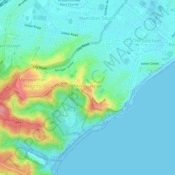
Name: Topografische Karte Merewether, Höhe, Relief.
Durchschnittliche Höhe: 23 m
Minimale Höhe: -1 m
Maximale Höhe: 109 m
Andere topografische Karten
Klicken Sie auf eine Karte, um ihre Topografie, ihre Höhe und ihr Relief anzuzeigen.
Bar Beach
Australia > New South Wales > Newcastle
Bar Beach, Newcastle, Newcastle-Maitland, Newcastle City Council, New South Wales, 2300, Australia
Durchschnittliche Höhe: 10 m
Whitebridge
Australia > New South Wales > Newcastle
Whitebridge, Newcastle, Newcastle-Maitland, Lake Macquarie City Council, New South Wales, 2290, Australia
Durchschnittliche Höhe: 64 m
Newcastle
Australia > New South Wales > Newcastle
Newcastle, Newcastle City Council, New South Wales, 2300, Australia
Durchschnittliche Höhe: 5 m
Killingworth
Australia > New South Wales > Newcastle
Killingworth, Newcastle, Newcastle-Maitland, Lake Macquarie City Council, New South Wales, 2278, Australia
Durchschnittliche Höhe: 60 m
Newcastle
Australia > New South Wales > Newcastle
Newcastle, Newcastle-Maitland, Newcastle City Council, New South Wales, 2300, Australia
Durchschnittliche Höhe: 9 m