
Spenden
Rüste dich für dein nächstes Abenteuer:
Als Amazon-Partner verdient diese Seite an qualifizierten Käufen, ohne dass Ihnen zusätzliche Kosten entstehen.
Topografische Karte Adger
Klicken Sie auf die Karte, um die Höhe anzuzeigen.
Spenden
Rüste dich für dein nächstes Abenteuer:
Als Amazon-Partner verdient diese Seite an qualifizierten Käufen, ohne dass Ihnen zusätzliche Kosten entstehen.
Über diese Karte
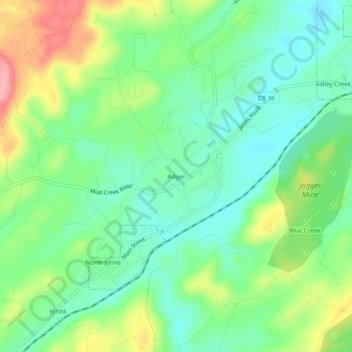
Name: Topografische Karte Adger, Höhe, Relief.
Ort: Adger, Jefferson County, Alabama, United States (33.35706 -87.11361 33.39706 -87.07361)
Durchschnittliche Höhe: 153 m
Minimale Höhe: 112 m
Maximale Höhe: 231 m
Spenden
Rüste dich für dein nächstes Abenteuer:
Als Amazon-Partner verdient diese Seite an qualifizierten Käufen, ohne dass Ihnen zusätzliche Kosten entstehen.
Andere topografische Karten
Klicken Sie auf eine Karte, um ihre Topografie, ihre Höhe und ihr Relief anzuzeigen.
Birmingham
United States > Alabama > Jefferson County
Birmingham has a varied and rugged topography shaped by the nearby Appalachian foothills. The city sits at an average elevation of around 600 feet (183 meters), though it is surrounded by more dramatic terrain that rises higher to 1,000 feet (305 meters) in some areas, particularly to the south and east.…
Durchschnittliche Höhe: 193 m
Spenden
Rüste dich für dein nächstes Abenteuer:
Als Amazon-Partner verdient diese Seite an qualifizierten Käufen, ohne dass Ihnen zusätzliche Kosten entstehen.
Fultondale
United States > Alabama > Jefferson County
Due to difficult topography, for many years Fultondale was limited in its ability to grow. However, as technology improved, the ability to convert what had been difficult to unusable land for retail and commercial purposes improved. The Colonial Promenade Fultondale development was a project of Colonial…
Durchschnittliche Höhe: 185 m
Spenden
Rüste dich für dein nächstes Abenteuer:
Als Amazon-Partner verdient diese Seite an qualifizierten Käufen, ohne dass Ihnen zusätzliche Kosten entstehen.
Spenden
Rüste dich für dein nächstes Abenteuer:
Als Amazon-Partner verdient diese Seite an qualifizierten Käufen, ohne dass Ihnen zusätzliche Kosten entstehen.
Grayson Valley
United States > Alabama > Jefferson County > Grayson Valley
Durchschnittliche Höhe: 296 m
Warrior
United States > Alabama > Jefferson County
Warrior is in the Central time zone. The elevation at the center of town is 564 feet (172 m), though it ranges from over 620 feet (190 m) north of the center to less than 300 feet (91 m) along the Locust Fork of the Black Warrior River, which forms the southern boundary of the city.
Durchschnittliche Höhe: 141 m
Spenden
Rüste dich für dein nächstes Abenteuer:
Als Amazon-Partner verdient diese Seite an qualifizierten Käufen, ohne dass Ihnen zusätzliche Kosten entstehen.
Spenden
Rüste dich für dein nächstes Abenteuer:
Als Amazon-Partner verdient diese Seite an qualifizierten Käufen, ohne dass Ihnen zusätzliche Kosten entstehen.
Spenden
Rüste dich für dein nächstes Abenteuer:
Als Amazon-Partner verdient diese Seite an qualifizierten Käufen, ohne dass Ihnen zusätzliche Kosten entstehen.
McDonald Chapel
United States > Alabama > Jefferson County > McDonald Chapel > West Ensley
Durchschnittliche Höhe: 186 m
Spenden
Rüste dich für dein nächstes Abenteuer:
Als Amazon-Partner verdient diese Seite an qualifizierten Käufen, ohne dass Ihnen zusätzliche Kosten entstehen.
Spenden
Rüste dich für dein nächstes Abenteuer:
Als Amazon-Partner verdient diese Seite an qualifizierten Käufen, ohne dass Ihnen zusätzliche Kosten entstehen.
Spenden
Rüste dich für dein nächstes Abenteuer:
Als Amazon-Partner verdient diese Seite an qualifizierten Käufen, ohne dass Ihnen zusätzliche Kosten entstehen.
Spenden
Rüste dich für dein nächstes Abenteuer:
Als Amazon-Partner verdient diese Seite an qualifizierten Käufen, ohne dass Ihnen zusätzliche Kosten entstehen.
Fultondale
United States > Alabama > Jefferson County
Due to difficult topography, for many years Fultondale was limited in its ability to grow. However, as technology improved, the ability to convert what had been difficult to unusable land for retail and commercial purposes improved. The Colonial Promenade Fultondale development was a project of Colonial…
Durchschnittliche Höhe: 185 m
Spenden
Rüste dich für dein nächstes Abenteuer:
Als Amazon-Partner verdient diese Seite an qualifizierten Käufen, ohne dass Ihnen zusätzliche Kosten entstehen.
Spenden
Rüste dich für dein nächstes Abenteuer:
Als Amazon-Partner verdient diese Seite an qualifizierten Käufen, ohne dass Ihnen zusätzliche Kosten entstehen.
Spenden
Rüste dich für dein nächstes Abenteuer:
Als Amazon-Partner verdient diese Seite an qualifizierten Käufen, ohne dass Ihnen zusätzliche Kosten entstehen.