
Topografische Karte Redcastle
Interaktive Karte
Klicken Sie auf die Karte, um die Höhe anzuzeigen.
Über diese Karte
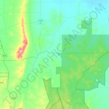
Name: Topografische Karte Redcastle, Höhe, Relief.
Ort: Redcastle, City of Greater Bendigo, Victoria, Australia (-36.79981 144.73889 -36.70570 144.93215)
Durchschnittliche Höhe: 192 m
Minimale Höhe: 125 m
Maximale Höhe: 421 m
Andere topografische Karten
Klicken Sie auf eine Karte, um ihre Topografie, ihre Höhe und ihr Relief anzuzeigen.
Katandra West
Katandra West, City of Greater Shepparton, Victoria, 3634, Australia
Durchschnittliche Höhe: 114 m
Tanjil Bren
Tanjil Bren, Shire of Baw Baw, Victoria, Australia
Durchschnittliche Höhe: 681 m
Mount Buller
Mount Buller, Shire of Mansfield, Victoria, 3723, Australia
Durchschnittliche Höhe: 824 m
Red Cliffs
Red Cliffs, Rural City of Mildura, Victoria, 3496, Australia
Durchschnittliche Höhe: 51 m
Northcote District
Australia > Victoria > Melbourne
Northcote District, Melbourne, City of Darebin, Victoria, Australia
Durchschnittliche Höhe: 44 m
Beechworth
Beechworth, Shire of Indigo, Victoria, 3747, Australia
Durchschnittliche Höhe: 484 m
Warranwood
Australia > Victoria > Melbourne
Warranwood, Melbourne, City of Maroondah, Victoria, 3134, Australia
Durchschnittliche Höhe: 131 m
Wonga Park
Australia > Victoria > Melbourne
Wonga Park, Melbourne, City of Manningham, Victoria, 3115, Australia
Durchschnittliche Höhe: 91 m
Hill View
Australia > Victoria > Cardigan Village
Hill View, Cardigan Village, City of Ballarat, Victoria, Australia
Durchschnittliche Höhe: 405 m
Mount Macedon
Mount Macedon, Shire of Macedon Ranges, Victoria, 3441, Australia
Durchschnittliche Höhe: 673 m
Launching Place
Australia > Victoria > Melbourne
Launching Place, Melbourne, Shire of Yarra Ranges, Victoria, 3139, Australia
Durchschnittliche Höhe: 162 m
Carisbrook
Carisbrook, Shire of Central Goldfields, Victoria, Australia
Durchschnittliche Höhe: 201 m
Shire of Mornington Peninsula
Shire of Mornington Peninsula, Victoria, Australia
Durchschnittliche Höhe: 23 m
Golden Point
Golden Point, Shire of Mount Alexander, Victoria, 3451, Australia
Durchschnittliche Höhe: 387 m
Clonbinane
Clonbinane, Shire of Mitchell, Victoria, 3658, Australia
Durchschnittliche Höhe: 457 m
Shire of Glenelg
Shire of Glenelg, Victoria, Australia
Durchschnittliche Höhe: 83 m
Brimbank Park
Australia > Victoria > Melbourne
Brimbank Park, Kealba, Melbourne, City of Brimbank, Victoria, 3021, Australia
Durchschnittliche Höhe: 52 m
Tarrington
Tarrington, Shire of Southern Grampians, Victoria, Australia
Durchschnittliche Höhe: 230 m
Tidal River
Tidal River, Wilsons Promontory, Shire of South Gippsland, Victoria, Australia
Durchschnittliche Höhe: 146 m
Rural City of Wangaratta
Rural City of Wangaratta, Victoria, Australia
Durchschnittliche Höhe: 435 m
Mount Hotham
Australia > Victoria > Hotham Heights
Mount Hotham, Hotham Heights, Victoria, Australia
Durchschnittliche Höhe: 1’635 m
Little River
Little River, City of Greater Geelong, Victoria, Australia, Little River
Durchschnittliche Höhe: 67 m
Meadow Creek
Meadow Creek, Rural City of Wangaratta, Victoria, Australia
Durchschnittliche Höhe: 257 m
Western Port
Western Port, Causeway Road Extension, French Island, Gippsland, Victoria, 3921, Australia
Durchschnittliche Höhe: 0 m
Rural City of Ararat
Rural City of Ararat, Victoria, Australia
Durchschnittliche Höhe: 297 m
Fraser Rise
Australia > Victoria > Melbourne
Fraser Rise, Melbourne, City of Melton, Victoria, 3336, Australia
Durchschnittliche Höhe: 119 m
Arbuckle Junction
Arbuckle Junction, Arbuckle, Shire of Wellington, Victoria, Australia
Durchschnittliche Höhe: 1’401 m
Gembrook District
Australia > Victoria > Melbourne
Gembrook District, Melbourne, Shire of Cardinia, Victoria, Australia
Durchschnittliche Höhe: 166 m
Lake Hume
Australia > Victoria > Tallangatta
Lake Hume, Tallangatta, Shire of Towong, Victoria, Australia
Durchschnittliche Höhe: 288 m
Kinglake National Park
Australia > Victoria > Melbourne
Kinglake National Park, Melbourne, Shire of Mitchell, Victoria, Australia
Durchschnittliche Höhe: 358 m
Silvan Reservoir
Australia > Victoria > Melbourne
Silvan Reservoir, Silvan, Melbourne, Shire of Yarra Ranges, Victoria, Australia
Durchschnittliche Höhe: 270 m
Shire of Wellington
Shire of Wellington, Victoria, Australia
Durchschnittliche Höhe: 331 m
Twelve Apostles
Australia > Victoria > Princetown
Twelve Apostles, Princetown, Shire of Corangamite, Victoria, 3269, Australia
Durchschnittliche Höhe: 31 m