
Topografische Karte Goodhue
Interaktive Karte
Klicken Sie auf die Karte, um die Höhe anzuzeigen.
Über diese Karte
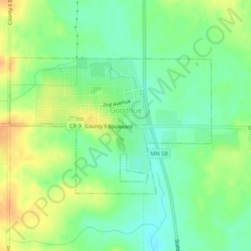
Name: Topografische Karte Goodhue, Höhe, Relief.
Ort: Goodhue, Goodhue County, Minnesota, 55027, United States (44.39069 -92.64151 44.40533 -92.61110)
Durchschnittliche Höhe: 346 m
Minimale Höhe: 328 m
Maximale Höhe: 370 m
Andere topografische Karten
Klicken Sie auf eine Karte, um ihre Topografie, ihre Höhe und ihr Relief anzuzeigen.
Zumbrota
United States > Minnesota > Goodhue County
Zumbrota, Goodhue County, Minnesota, 55992, United States
Durchschnittliche Höhe: 312 m
Kenyon
United States > Minnesota > Goodhue County
Kenyon, Goodhue County, Minnesota, United States
Durchschnittliche Höhe: 351 m
Dennison
United States > Minnesota > Goodhue County
Dennison, Goodhue County, Minnesota, United States
Durchschnittliche Höhe: 303 m
Frontenac
United States > Minnesota > Goodhue County
Frontenac, Florence Township, Goodhue County, Minnesota, 55026, United States
Durchschnittliche Höhe: 243 m
Red Wing
United States > Minnesota > Goodhue County
Red Wing, Goodhue County, Minnesota, United States
Durchschnittliche Höhe: 263 m
Wanamingo
United States > Minnesota > Goodhue County
Wanamingo, Goodhue County, Minnesota, 55983, United States
Durchschnittliche Höhe: 325 m
Pine Island
United States > Minnesota > Goodhue County
Pine Island, Goodhue County, Minnesota, United States
Durchschnittliche Höhe: 327 m
Welch
United States > Minnesota > Goodhue County
Welch, Welch Township, Goodhue County, Minnesota, United States
Durchschnittliche Höhe: 277 m
Cannon Falls
United States > Minnesota > Goodhue County > Cannon Falls > Cannon Falls
Cannon Falls, Goodhue County, Minnesota, 55009, United States
Durchschnittliche Höhe: 268 m
Cannon Falls
United States > Minnesota > Goodhue County
Cannon Falls, Goodhue County, Minnesota, 55009, United States
Durchschnittliche Höhe: 276 m