
Topografische Karte Wake Forest
Interaktive Karte
Klicken Sie auf die Karte, um die Höhe anzuzeigen.
Über diese Karte
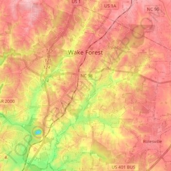
Name: Topografische Karte Wake Forest, Höhe, Relief.
Durchschnittliche Höhe: 105 m
Minimale Höhe: 18 m
Maximale Höhe: 153 m
Wake Forest is located in the northeast-central region of North Carolina, where the North American Piedmont and Atlantic Coastal Plain regions meet. This area is known as the "Fall Line" because it marks the elevation inland at which waterfalls begin to appear in creeks and rivers. Its central Piedmont location situates Wake Forest approximately three hours by car west of Atlantic Beach, and four hours east of the Great Smoky Mountains.
Andere topografische Karten
Klicken Sie auf eine Karte, um ihre Topografie, ihre Höhe und ihr Relief anzuzeigen.
Holly Springs
United States > North Carolina > Wake County
Holly Springs, Wake County, North Carolina, 27540, United States
Durchschnittliche Höhe: 115 m
Raleigh
United States > North Carolina > Wake County
Raleigh, Wake County, North Carolina, United States
Durchschnittliche Höhe: 103 m
Raleigh
United States > North Carolina > Wake County
Raleigh, Wake County, North Carolina, United States, Drainage for Lafeyette Village
Durchschnittliche Höhe: 126 m
Fuquay-Varina
United States > North Carolina > Wake County
Fuquay-Varina, Wake County, North Carolina, 27526, United States
Durchschnittliche Höhe: 113 m
Cary
United States > North Carolina > Wake County
Cary, Wake County, North Carolina, United States
Durchschnittliche Höhe: 111 m
Town of Garner
United States > North Carolina > Wake County > Town of Garner
Town of Garner, Wake County, North Carolina, United States
Durchschnittliche Höhe: 98 m
Apex
United States > North Carolina > Wake County
Apex, Wake County, North Carolina, 27502, United States
Durchschnittliche Höhe: 115 m