
Spenden
Rüste dich für dein nächstes Abenteuer:
Als Amazon-Partner verdient diese Seite an qualifizierten Käufen, ohne dass Ihnen zusätzliche Kosten entstehen.
Topografische Karte Bluefield
Klicken Sie auf die Karte, um die Höhe anzuzeigen.
Spenden
Rüste dich für dein nächstes Abenteuer:
Als Amazon-Partner verdient diese Seite an qualifizierten Käufen, ohne dass Ihnen zusätzliche Kosten entstehen.
Bluefield
Bluefield is a mountain city with a warm-summer humid continental climate (Dfb) bordering on subtropical highland climate or temperate oceanic climate (Cfb), due to its elevation. It is characterized by moderately cold, snowy winters and pleasantly warm to hot summers. The normal monthly mean daily temperature ranges from 31.9 °F (−0.1 °C) in January to 70.3 °F (21.3 °C) in July; on average, there are only 2.5 days with a maximum of at least 90 °F (32 °C) or greater maxima, 1.3 days of minima at or below 0 °F (−18 °C), and 23 days where the maximum does not rise above freezing. The hottest temperature ever recorded in the city was 99 °F (37 °C), set on July 28, 1952, and August 9, 1957, with the coldest temperature at −25 °F (−32 °C), set on December 30, 1917.
Spenden
Rüste dich für dein nächstes Abenteuer:
Als Amazon-Partner verdient diese Seite an qualifizierten Käufen, ohne dass Ihnen zusätzliche Kosten entstehen.
Über diese Karte
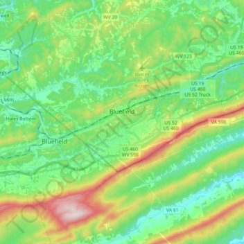
Name: Topografische Karte Bluefield, Höhe, Relief.
Durchschnittliche Höhe: 819 m
Minimale Höhe: 630 m
Maximale Höhe: 1’248 m
Spenden
Rüste dich für dein nächstes Abenteuer:
Als Amazon-Partner verdient diese Seite an qualifizierten Käufen, ohne dass Ihnen zusätzliche Kosten entstehen.
Andere topografische Karten
Klicken Sie auf eine Karte, um ihre Topografie, ihre Höhe und ihr Relief anzuzeigen.
Spenden
Rüste dich für dein nächstes Abenteuer:
Als Amazon-Partner verdient diese Seite an qualifizierten Käufen, ohne dass Ihnen zusätzliche Kosten entstehen.
Spenden
Rüste dich für dein nächstes Abenteuer:
Als Amazon-Partner verdient diese Seite an qualifizierten Käufen, ohne dass Ihnen zusätzliche Kosten entstehen.