
Topografische Karte Daporijo
Interaktive Karte
Klicken Sie auf die Karte, um die Höhe anzuzeigen.
Über diese Karte
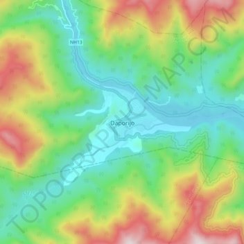
Name: Topografische Karte Daporijo, Höhe, Relief.
Durchschnittliche Höhe: 541 m
Minimale Höhe: 216 m
Maximale Höhe: 1’171 m
Daporijo is located at an elevation of 600 m above sea level. It is located beside the river Subansiri, one of the principal rivers of Arunachal Pradesh, and a major tributary of the mighty Brahmaputra Daporijo valley is surrounded by Evergreen hills in three corners and Subansiri river in the other.