
Topografische Karte Polangui
Interaktive Karte
Klicken Sie auf die Karte, um die Höhe anzuzeigen.
Über diese Karte
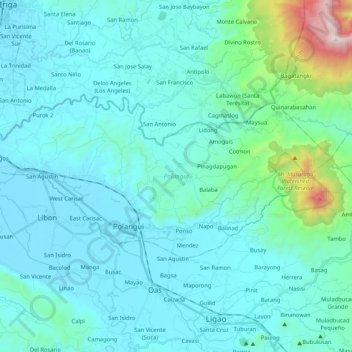
Name: Topografische Karte Polangui, Höhe, Relief.
Ort: Polangui, Albay, Bicol Region, 4506, Philippines (13.27558 123.39574 13.37009 123.60484)
Durchschnittliche Höhe: 192 m
Minimale Höhe: 7 m
Maximale Höhe: 1’596 m
known during the early times that the barrio has vas and fertile agricultural land, and because of this, settlers from nearby places migrated to this barrio to venture in agricultural farming. One of the early settlers who migrated to this barrio came from barrio La Medalla, town of Iriga (now a City) of the Province of Camarines Sur; they were so industrious, hardworking and adventurous. They brought along with them their patroness saint, Sta, La Medalla as they settled in this place. And, as a token of gratitude, they donated their patroness saint to the barrio. And with this, the resident decided that Sta. La Medalla be their patroness saint in their barrio in the honor of her, thus, it became barrio La Medalla. The 1st Teniente del barrio” (now known as PABLO BALANG, followed in succession, by SANTOS LAYNES, SANTOS AMOROSO, NEMESIO RAMBOYONG, MARTIN CERVANTES, RESTITUTO BALANG, AMANDO BARRA & presently by OLIVA O. SALCEDO) Barangay La Medalla is situated at the North-Western part of Polangui with a distance of approximately 8.5 kilometers far from centro Poblacion, located along the North: Barangay Lourdes, South: Barangay Apad, Santicon, West: Barangay La Purisima & East: Barangay Kinuartelan. Its topography was plain, Mountainous (Bulod ) and Hilly. Its classification was Poblacion, coastals, along the highway & Interior. Barangay La Medalla is divided into (7) Puroks managed by Purok Leaders & Advisers. It has an exciting complete Elementary School established in 1933 and a high school established on 1992. It has a Barangay Hall, Health Center and a Day Care Center. Residents buy their daily basic provision in a few sari-sari stores but most of the time they prefer to but in a town proper during market day. Today, like other barangay in Polangui, La Medalla is loving forward for progress. The only problem which the residents are facing now is transportation wherein only motorcycle is the only means because of rough roads connecting the barangay to poblacion.
Andere topografische Karten
Klicken Sie auf eine Karte, um ihre Topografie, ihre Höhe und ihr Relief anzuzeigen.
Mayon Skyline
Philippines > Albay > Tabaco
Mayon Skyline, Mount Mayon Park Road, Tabaco, Albay, Bicol Region, 4511, Philippines
Durchschnittliche Höhe: 742 m
Cruzada
Philippines > Albay > Legazpi
Cruzada, Legazpi, Albay, Bicol Region, 4500, Philippines
Durchschnittliche Höhe: 19 m
Oras
Philippines > Albay > Tabaco
Oras, Tabaco, Albay, Bicol Region, 4511, Philippines
Durchschnittliche Höhe: 232 m
Lamba
Philippines > Albay > Legazpi
Lamba, Legazpi, Albay, Bicol Region, 4500, Philippines
Durchschnittliche Höhe: 26 m
Cabagñan East
Philippines > Albay > Legazpi
Cabagñan East, Legazpi, Albay, Bicol Region, 4500, Philippines
Durchschnittliche Höhe: 21 m
Camalig
Camalig, Albay, Bicol Region, 4502, Philippines
Durchschnittliche Höhe: 191 m
San Jose
Philippines > Albay > Malilipot
San Jose, Malilipot, Albay, Bicol Region, 4510, Philippines
Durchschnittliche Höhe: 114 m
Matacon
Philippines > Albay > Polangui
Matacon, Polangui, Albay, Bicol Region, 4506, Philippines
Durchschnittliche Höhe: 36 m
Oson
Philippines > Albay > Tabaco
Oson, Tabaco, Albay, Bicol Region, 4511, Philippines
Durchschnittliche Höhe: 206 m
Guinobatan
Guinobatan, Albay, Bicol Region, 4503, Philippines
Durchschnittliche Höhe: 158 m
Kawit-East Washington Drive
Philippines > Albay > Legazpi
Kawit-East Washington Drive, Legazpi, Albay, Bicol Region, 4500, Philippines
Durchschnittliche Höhe: 30 m
Sipi
Philippines > Albay > Daraga
Sipi, Daraga, Albay, Bicol Region, 4501, Philippines
Durchschnittliche Höhe: 64 m
Peñafrancia
Philippines > Albay > Daraga
Peñafrancia, Daraga, Albay, Bicol Region, 4501, Philippines
Durchschnittliche Höhe: 88 m
PNR - Peñaranda
Philippines > Albay > Legazpi
PNR - Peñaranda, Legazpi, Albay, Bicol Region, 4500, Philippines
Durchschnittliche Höhe: 7 m
Tabaco
Tabaco, Albay, Bicol Region, 4511, Philippines
Durchschnittliche Höhe: 164 m
Barangay 5
Philippines > Albay > Malilipot
Barangay 5, Malilipot, Albay, Bicol Region, 4510, Philippines
Durchschnittliche Höhe: 77 m
Malabog
Philippines > Albay > Daraga
Malabog, Daraga, Albay, Bicol Region, 4502, Philippines
Durchschnittliche Höhe: 142 m
Tuburan
Tuburan, Albay, Bicol Region, 4504, Philippines
Durchschnittliche Höhe: 70 m
Malinao
Malinao, Albay, Bicol Region, 4514, Philippines
Durchschnittliche Höhe: 17 m
Victory Village South
Victory Village South, Albay, Bicol Region, 4500, Philippines
Durchschnittliche Höhe: 13 m
Mayon Volcano
Philippines > Albay > Magapo
Mayon Volcano, Mt. Mayon Park Road, Magapo, Albay, Bicol Region, Philippines
Durchschnittliche Höhe: 519 m
Bañag
Philippines > Albay > Bañag
Bañag, Albay, Bicol Region, 4501, Philippines
Durchschnittliche Höhe: 52 m
Tiwi
Philippines > Albay > Tiwi
Tiwi, Albay, Bicol Region, 4513, Philippines
Durchschnittliche Höhe: 44 m
Cabangan West
Cabangan West, Albay, Bicol Region, 4500, Philippines
Durchschnittliche Höhe: 29 m
Ilawod West Poblacion
Philippines > Albay > Legazpi > Ilawod West Poblacion
Ilawod West Poblacion, Legazpi, Albay, Bicol Region, 4500, Philippines
Durchschnittliche Höhe: 47 m
Mount Malinao
Mount Malinao, Albay, Bicol Region, Philippines
Durchschnittliche Höhe: 964 m
Legazpi
Legazpi, Albay, Bicol Region, 4500, Philippines
Durchschnittliche Höhe: 124 m
Em's Barrio South
Philippines > Albay > Legazpi > Em's Barrio South
Em's Barrio South, Legazpi, Albay, Bicol Region, 4500, Philippines
Durchschnittliche Höhe: 53 m
Polangui
Polangui, Albay, Bicol Region, 4506, Philippines
Durchschnittliche Höhe: 54 m
Mount Masaraga
Philippines > Albay > Ligao
Mount Masaraga, Ligao, Albay, Bicol Region, Philippines
Durchschnittliche Höhe: 752 m
Mount Mayon
Philippines > Albay > Tabaco
Mount Mayon, Tabaco, Albay, Bicol Region, 4511, Philippines
Durchschnittliche Höhe: 1’696 m
Tabaco
Tabaco, Albay, Bicol Region, 4511, Philippines
Durchschnittliche Höhe: 182 m