
Topografische Karte Kinston
Interaktive Karte
Klicken Sie auf die Karte, um die Höhe anzuzeigen.
Über diese Karte
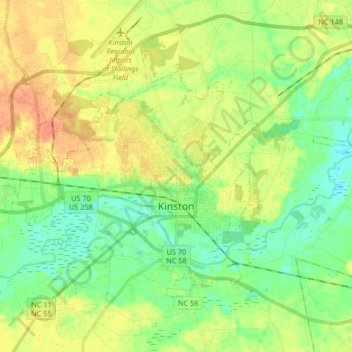
Name: Topografische Karte Kinston, Höhe, Relief.
Ort: Kinston, Lenoir County, North Carolina, United States (35.22583 -77.66264 35.32253 -77.49801)
Durchschnittliche Höhe: 19 m
Minimale Höhe: 2 m
Maximale Höhe: 40 m
Andere topografische Karten
Klicken Sie auf eine Karte, um ihre Topografie, ihre Höhe und ihr Relief anzuzeigen.
Pink Hill
United States > North Carolina > Lenoir County
Pink Hill, Lenoir County, North Carolina, United States
Durchschnittliche Höhe: 43 m
Clubview
United States > North Carolina > Lenoir County > Kinston
Clubview, Kinston, Lenoir County, North Carolina, 28503, United States
Durchschnittliche Höhe: 24 m
Savannah
United States > North Carolina > Lenoir County
Savannah, Lenoir County, North Carolina, United States
Durchschnittliche Höhe: 21 m