Geolokalisieren

Topografische Karte Splendora

Klicken Sie auf die Karte, um die Höhe anzuzeigen.

👉 Easily get elevation data in JSON, GeoTIFF and KML formats using Elevation API
Vielen Dank für die Unterstützung dieser Website ❤️
Spenden

Über diese Karte

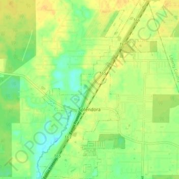
Name: Topografische Karte Splendora, Höhe, Relief.

Ort: Splendora, Montgomery County, Texas, 77372, United States (30.20831 -95.18246 30.27156 -95.13354)

Durchschnittliche Höhe: 37 m

Minimale Höhe: 24 m

Maximale Höhe: 47 m

Andere topografische Karten

Klicken Sie auf eine Karte, um ihre Topografie, ihre Höhe und ihr Relief anzuzeigen.

New Caney

United States > Texas > Montgomery County

Durchschnittliche Höhe: 30 m

Porter

United States > Texas > Montgomery County

Durchschnittliche Höhe: 30 m

Stillwater Community

United States > Texas > Montgomery County > Conroe

Durchschnittliche Höhe: 44 m

Mount Zion

United States > Texas > Montgomery County

Durchschnittliche Höhe: 88 m

Bobville

United States > Texas > Montgomery County

Durchschnittliche Höhe: 75 m

Wild Ridge

United States > Texas > Montgomery County > The Woodlands

Durchschnittliche Höhe: 44 m

Lakeland

United States > Texas > Montgomery County

Durchschnittliche Höhe: 44 m

Conroe

United States > Texas > Montgomery County > Conroe > Conroe

Durchschnittliche Höhe: 60 m

Benders Landing

United States > Texas > Montgomery County

Durchschnittliche Höhe: 29 m

Sterling Ridge

United States > Texas > Montgomery County > The Woodlands

Durchschnittliche Höhe: 58 m

Security

United States > Texas > Montgomery County

Durchschnittliche Höhe: 53 m

Porter

United States > Texas > Montgomery County

Durchschnittliche Höhe: 30 m

Woodland Hills

United States > Texas > Montgomery County > Conroe

Durchschnittliche Höhe: 99 m

Stillwater Community

United States > Texas > Montgomery County > Conroe

Durchschnittliche Höhe: 44 m

Indian Springs

United States > Texas > Montgomery County > The Woodlands

Durchschnittliche Höhe: 48 m

LITTLE LAKE CONROE

United States > Texas > Montgomery County > Conroe

Durchschnittliche Höhe: 77 m

New Caney

United States > Texas > Montgomery County

Durchschnittliche Höhe: 30 m

Rüste dich für dein nächstes Abenteuer:

🧖Mikrofaser-Handtücher - Schnelltrocknend und extrem platzsparend
🕯️Sturmlaternen - Atmosphärisches Licht für die Alphütte
🍽️Campinggeschirr-Sets - Leichtes und stapelbares Geschirr für Unterwegs
🔥Feuerstahl - Zuverlässiges Feuermachen bei jedem Wetter
🧥Hardshelljacken - Extremer Wetterschutz für alpine Touren in der Schweiz

Als Amazon-Partner verdient diese Seite an qualifizierten Käufen, ohne dass Ihnen zusätzliche Kosten entstehen.