
Topografische Karte Salisbury
Interaktive Karte
Klicken Sie auf die Karte, um die Höhe anzuzeigen.
Über diese Karte
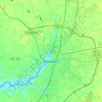
Name: Topografische Karte Salisbury, Höhe, Relief.
Ort: Salisbury, Wicomico County, Maryland, United States (38.32695 -75.64292 38.42711 -75.50357)
Durchschnittliche Höhe: 12 m
Minimale Höhe: -3 m
Maximale Höhe: 30 m
According to the United States Census Bureau, the city has a total area of 13.87 square miles (35.92 km2), of which 13.40 square miles (34.71 km2) is land and 0.47 square miles (1.22 km2) is water. The city has a varying elevation of 17 to 45 feet (5.2 to 13.7 m) above sea level.
Andere topografische Karten
Klicken Sie auf eine Karte, um ihre Topografie, ihre Höhe und ihr Relief anzuzeigen.
Quantico
United States > Maryland > Wicomico County
Quantico, Wicomico County, Maryland, United States
Durchschnittliche Höhe: 6 m
Stellas Venture
United States > Maryland > Wicomico County
Stellas Venture, Wicomico County, Maryland, United States
Durchschnittliche Höhe: 19 m
Walston Switch
United States > Maryland > Wicomico County
Walston Switch, Wicomico County, Maryland, 21849, United States
Durchschnittliche Höhe: 18 m
Salisbury
United States > Maryland > Wicomico County > Salisbury
Salisbury, Wicomico County, Maryland, 21803, United States
Durchschnittliche Höhe: 11 m
Fruitland
United States > Maryland > Wicomico County
Fruitland, Wicomico County, Maryland, 21826, United States
Durchschnittliche Höhe: 11 m
Delmar
United States > Maryland > Wicomico County
Delmar, Wicomico County, Maryland, 19940, United States
Durchschnittliche Höhe: 15 m