
Topografische Karte Bello
Klicken Sie auf die Karte, um die Höhe anzuzeigen.
Über diese Karte
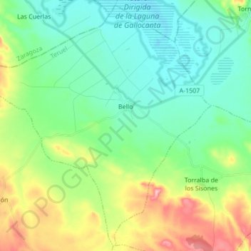
Name: Topografische Karte Bello, Höhe, Relief.
Ort: Bello, Jiloca, Teruel, Aragón, España (40.86518 -1.58956 40.96412 -1.45346)
Durchschnittliche Höhe: 1’037 m
Minimale Höhe: 989 m
Maximale Höhe: 1’153 m
Andere topografische Karten
Klicken Sie auf eine Karte, um ihre Topografie, ihre Höhe und ihr Relief anzuzeigen.
Lago de Barasona
España > Aragón > La Puebla de Castro > Lago de Barasona
Durchschnittliche Höhe: 517 m
Cerler
Cerler (Sarllé en aragonés benasqués) es una localidad perteneciente al municipio de Benasque considerado el pueblo más alto del Pirineo aragonés por hallarse enclavado a 1540 metros de altitud, delante de Villarrué (1534 m s. n. m.) en el municipio de Laspaúles, según el Instituto Geográfico Nacional.
Durchschnittliche Höhe: 1’601 m
Parque Natural Posets-Maladeta
España > Aragón > La Ribagorza
La vida se escalona según la altura y las condiciones ambientales. A menor altitud nos encontramos serbales, avellanos y abedules, en las laderas más húmedas aparecen hayas, pinos y abetos, y en las cotas más altas el pino silvestre da paso al pino negro. Entre esta vegetación se cobija una variada fauna.…
Durchschnittliche Höhe: 1’897 m
Somport
España > Aragón > La Jacetania > Candanchú
Somport (en francés Col du Somport) es un puerto de montaña de los Pirineos, con una altitud de 1640 metros. En los alrededores se encuentran las estaciones de esquí de Candanchú, Astún y Le Somport.
Durchschnittliche Höhe: 1’727 m
Zaragoza
En la ribera y en el área urbana, el terreno es llano por lo general, sobre todo en la parte norte de la ciudad asentada en la margen derecha de la desembocadura del río Gállego, mientras que la sur tiene una inclinación más pronunciada conforme se aleja del Ebro. La altura del río Ebro a su paso por…
Durchschnittliche Höhe: 310 m
Peralta de la Sal
Peralta de la Sal es una localidad española integrante del municipio de Peralta de Calasanz, en la Litera, provincia de Huesca (Aragón). Está situada bajo los barrancos de Calasanz y Gabasa, a la orilla del río Sosa, a 523 m de altitud. Con 142 de habitantes (INE 2022). El término confina por el Norte con…
Durchschnittliche Höhe: 588 m
Cerro de la Silla (Cima este)
España > Aragón > Campo de Cariñena > Cosuenda
Durchschnittliche Höhe: 950 m
Alastuey
España > Aragón > La Jacetania > Bailo
Se trata de un reducido caserío de origen medieval integrado en el municipio de Bailo. Situado en las estribaciones occidentales de la Sierra de San Juan de la Peña en un cerro a 826 m de altitud y organizado en torno a una plaza con un pozo comunal convertido en fuente.
Durchschnittliche Höhe: 833 m
El Tormillo
España > Aragón > Somontano de Barbastro > Peralta de Alcofea
Durchschnittliche Höhe: 440 m
Pico Aneto
El Aneto es el pico más elevado de los Pirineos y el segundo más alto de la península ibérica, con una altitud de 3404 metros sobre el nivel del mar. Se encuentra situado en el Parque natural Posets-Maladeta, en el municipio español de Benasque, provincia de Huesca, comunidad autónoma de Aragón.
Durchschnittliche Höhe: 2’925 m
Sistema Ibérico
España > Aragón > Tarazona y el Moncayo > Tarazona
El sistema Ibérico es un sistema montañoso de altitud media ubicada en el interior de la península ibérica, en España. Algunos de sus picos más altos son el Moncayo (2315 m s. n. m.), su cumbre de mayor altitud, el monte San Lorenzo (2271 m s. n. m.), el pico de Urbión (2228 m s. n. m.), el…
Durchschnittliche Höhe: 1’906 m
Río Ebro
España > Aragón > Ribera Alta del Ebro > Torres de Berrellén
Tradicionalmente se ha considerado que el Ebro nace en Fontibre (del latín Fontes Hiberis o fuentes del Ebro), manantial situado a 880 m s. n. m. de altitud en la Hermandad de Campoo de Suso, en Cantabria.
Durchschnittliche Höhe: 234 m
La Virgen de la Vega
España > Aragón > Gúdar-Javalambre > Alcalá de la Selva
Durchschnittliche Höhe: 1’479 m
Pico El Sombrero
España > Aragón > Gúdar-Javalambre > Mora de Rubielos
Durchschnittliche Höhe: 1’135 m
Río Ebro
España > Aragón > Ribera Alta del Ebro > Luceni
Tradicionalmente se ha considerado que el Ebro nace en Fontibre (del latín Fontes Hiberis o fuentes del Ebro), manantial situado a 880 m s. n. m. de altitud en la Hermandad de Campoo de Suso, en Cantabria.
Durchschnittliche Höhe: 223 m
Monte Perdido
Monte Perdido es el macizo calcáreo más alto de Europa. Se encuentra situado dentro de la vertiente sur del Pirineo central, al norte de la provincia de Huesca, en el parque nacional de Ordesa y Monte Perdido, en la comunidad autónoma de Aragón (España). Su pico más elevado es el Monte Perdido, con una…
Durchschnittliche Höhe: 2’806 m