
Topografische Karte Genua
Klicken Sie auf die Karte, um die Höhe anzuzeigen.
Genua
In den 1980er Jahren kam das Bevölkerungswachstum schließlich ins Stocken, um sich in den folgenden Jahren in eine „Bevölkerungsimplosion“ zu verwandeln. Von 816.000 Einwohnern 1971 sank die Population auf 610.000 im Jahre 2001 (das bedeutet eine Bevölkerungsminderung von 25 % innerhalb von 30 Jahren). Begünstigt wurde diese Entwicklung durch das sehr hohe Durchschnittsalter, das eine höhere Sterberate im Vergleich zur Geburtenrate mit sich brachte (2006: 4680 Geburten bei 8158 Sterbefällen). Das Durchschnittsalter der Genueser liegt bei 47,0 Jahren, mit einem Höchstwert von 48,5 Jahren im Stadtgebiet des Medio Levante. Der Altenquotient (Verhältnis von den über 65-Jährigen zu den unter 15-Jährigen) liegt bei 242,0. Im März 2007 lebten 288.616 (47 %) Männer und 325.525 (53 %) Frauen in Genua.
Über diese Karte
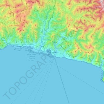
Name: Topografische Karte Genua, Höhe, Relief.
Ort: Genua, Ligurien, 16100, Italien (44.24726 8.77386 44.56726 9.09386)
Durchschnittliche Höhe: 247 m
Minimale Höhe: -4 m
Maximale Höhe: 1’486 m
Andere topografische Karten
Klicken Sie auf eine Karte, um ihre Topografie, ihre Höhe und ihr Relief anzuzeigen.