
Topografische Karte Santa Cruz
Interaktive Karte
Klicken Sie auf die Karte, um die Höhe anzuzeigen.
Über diese Karte
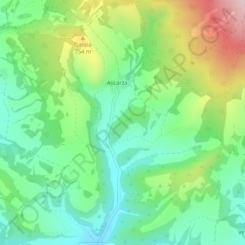
Name: Topografische Karte Santa Cruz, Höhe, Relief.
Durchschnittliche Höhe: 670 m
Minimale Höhe: 575 m
Maximale Höhe: 852 m
Andere topografische Karten
Klicken Sie auf eine Karte, um ihre Topografie, ihre Höhe und ihr Relief anzuzeigen.
La Dehesa
España > Castilla y León > Condado de Treviño
La Dehesa, Condado de Treviño, Burgos, Castilla y León, España
Durchschnittliche Höhe: 817 m
Treviño
España > Castilla y León > Condado de Treviño
Treviño, Condado de Treviño, Burgos, Castilla y León, España
Durchschnittliche Höhe: 602 m
Doroño
España > Castilla y León > Condado de Treviño > Doroño
Doroño, Condado de Treviño, Ebro, Burgos, Castilla y León, España
Durchschnittliche Höhe: 738 m
Arrieta
España > Castilla y León > Condado de Treviño > Arrieta
Arrieta, Condado de Treviño, Miranda de Ebro, Castilla y León, España
Durchschnittliche Höhe: 689 m
Otero
España > Castilla y León > Condado de Treviño
Otero, Condado de Treviño, Miranda de Ebro, Castilla y León, España
Durchschnittliche Höhe: 716 m