Topografische Karte Cingoli
Klicken Sie auf die Karte, um die Höhe anzuzeigen.
Cingoli
The town occupies the site of the ancient Cingulum, a town of Picenum, founded and strongly fortified by Julius Caesar's lieutenant Titus Labienus (probably on the site of an earlier village) in 63 BCE at his own expense. Its lofty position at an elevation of about 650 metres (2,130 ft) made it of some importance in the civil wars, but otherwise little is heard of it. Under the Roman Empire it was a municipium.
Über diese Karte
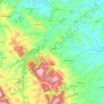
Name: Topografische Karte Cingoli, Höhe, Relief.
Ort: Cingoli, Macerata, Marche, 62011, Italy (43.32164 13.12186 43.46133 13.33633)
Durchschnittliche Höhe: 330 m
Minimale Höhe: 101 m
Maximale Höhe: 854 m
Andere topografische Karten
Klicken Sie auf eine Karte, um ihre Topografie, ihre Höhe und ihr Relief anzuzeigen.


Castelletta I
Italy > Marche > Macerata > Civitanova Marche > Civitanova Alta
Durchschnittliche Höhe: 41 m