
Spenden
Rüste dich für dein nächstes Abenteuer:
Als Amazon-Partner verdient diese Seite an qualifizierten Käufen, ohne dass Ihnen zusätzliche Kosten entstehen.
Topografische Karte Muntho Dhalo
Klicken Sie auf die Karte, um die Höhe anzuzeigen.
Spenden
Rüste dich für dein nächstes Abenteuer:
Als Amazon-Partner verdient diese Seite an qualifizierten Käufen, ohne dass Ihnen zusätzliche Kosten entstehen.
Über diese Karte
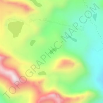
Name: Topografische Karte Muntho Dhalo, Höhe, Relief.
Ort: Muntho Dhalo, Sham Valley, India (34.75569 76.47986 34.75579 76.47996)
Durchschnittliche Höhe: 4’847 m
Minimale Höhe: 4’532 m
Maximale Höhe: 5’278 m
Spenden
Rüste dich für dein nächstes Abenteuer:
Als Amazon-Partner verdient diese Seite an qualifizierten Käufen, ohne dass Ihnen zusätzliche Kosten entstehen.
Andere topografische Karten
Klicken Sie auf eine Karte, um ihre Topografie, ihre Höhe und ihr Relief anzuzeigen.
Bengaluru
India > Karnataka > Bangalore North
Bengaluru (formerly Bangalore) is situated in the southeastern part of Karnataka, India, within the Bengaluru Urban district. It lies at an elevation of approximately 900 meters (3,000 feet) above sea level, on the Deccan Plateau. This elevated position gives the city a moderate climate, with temperatures…
Durchschnittliche Höhe: 886 m
Chennai
Chennai is located on the southeastern coast of India in the northeastern part of Tamil Nadu on a flat coastal plain known as the Eastern Coastal Plains with an average elevation of 6.7 m (22 ft) and highest point at 60 m (200 ft). Chennai's soil is mostly clay, shale and sandstone. Clay underlies most of the…
Durchschnittliche Höhe: 8 m
Hyderabad
India > Telangana > Bahadurpura mandal
Hyderabad (/ˈhaɪdərəbæd/ HY-dər-ə-bad; Telugu: [ˈɦaɪ̯daraːbaːd], Urdu: [ˈɦɛːdəɾaːbaːd]) is the capital and largest city of the Indian state of Telangana. It occupies 650 km2 (250 sq mi) on the Deccan Plateau along the banks of the Musi River, in the northern part of Southern India. With an…
Durchschnittliche Höhe: 549 m
Spenden
Rüste dich für dein nächstes Abenteuer:
Als Amazon-Partner verdient diese Seite an qualifizierten Käufen, ohne dass Ihnen zusätzliche Kosten entstehen.
Mumbai
India > Maharashtra > Mumbai
Mumbai is on a narrow peninsula on the southwest of Salsette Island, which lies between the Arabian Sea to the west, Thane Creek to the east and Vasai Creek to the north. Mumbai's suburban district occupies most of the island. Navi Mumbai is east of Thane Creek and Thane is north of Vasai Creek. Mumbai…
Durchschnittliche Höhe: 18 m
Tamil Nadu
The annual rainfall of the state is about 945 mm (37.2 in) of which 48 per cent is through the northeast monsoon, and 32 per cent through the southwest monsoon. Since the state is entirely dependent on rains for recharging its water resources, monsoon failures lead to acute water scarcity and severe drought.…
Durchschnittliche Höhe: 253 m
West Bengal
The distribution of vegetation in northern West Bengal is dictated by elevation and precipitation. For example, the foothills of the Himalayas, the Dooars, are densely wooded with sal and other tropical evergreen trees. Above an elevation of 1,000 metres (3,300 ft), the forest becomes predominantly…
Durchschnittliche Höhe: 182 m
Spenden
Rüste dich für dein nächstes Abenteuer:
Als Amazon-Partner verdient diese Seite an qualifizierten Käufen, ohne dass Ihnen zusätzliche Kosten entstehen.
Maharashtra
Maharashtra with a total area of 307,713 km2 (118,809 sq mi), is the third-largest state by area in terms of land area and constitutes 9.36 per cent of India's total geographical area. The State lies between 15°35' N to 22°02' N latitude and 72°36' E to 80°54' E longitude. It occupies the western and…
Durchschnittliche Höhe: 346 m
Kerala
Kerala was alternatively called Malabar in the foreign trade circles. Earlier, the term Malabar had also been used to denote Tulu Nadu and Kanyakumari which lie contiguous to Kerala on the southwestern coast of India, in addition to the modern state of Kerala. The people of Malabar were known as Malabars.…
Durchschnittliche Höhe: 251 m
Idukki
Though it is the second-largest district in the region in terms of area, it has the lowest population density among the districts of Kerala. There are only two municipalities in the district and the urban population is comparatively much lower than the rural population, due to its mountainous nature. The 2,695…
Durchschnittliche Höhe: 607 m
Spenden
Rüste dich für dein nächstes Abenteuer:
Als Amazon-Partner verdient diese Seite an qualifizierten Käufen, ohne dass Ihnen zusätzliche Kosten entstehen.
Nagaland
Nagaland lies between 93°20'E and 95°15'E longitude and between 25°6'N and 27°4'N latitude. It is largely a mountainous state. The Naga Hills rise from the Brahmaputra Valley in Assam to about 610 metres (2,000 ft) and rise further to the southeast, as high as 1,800 metres (6,000 ft). Mount Saramati at an…
Durchschnittliche Höhe: 824 m
Bengaluru
India > Karnataka > Bangalore North
Bengaluru (formerly Bangalore) is situated in the southeastern part of Karnataka, India, within the Bengaluru Urban district. It lies at an elevation of approximately 900 meters (3,000 feet) above sea level, on the Deccan Plateau. This elevated position gives the city a moderate climate, with temperatures…
Durchschnittliche Höhe: 881 m
Pauri Garhwal
The mountains of Khirsu offer views of the northern Himalayas and attract a large number of tourists. Located 19 kilometres (12 mi) away from Pauri at an altitude of 1,700 metres (5,600 ft), Khirsu is peaceful and free from pollution. There is the nearby ancient temple of Ghandiyal Devta. Accommodation is…
Durchschnittliche Höhe: 958 m
Spenden
Rüste dich für dein nächstes Abenteuer:
Als Amazon-Partner verdient diese Seite an qualifizierten Käufen, ohne dass Ihnen zusätzliche Kosten entstehen.
Uttarakhand
Uttarakhand lies on the southern slope of the Himalaya range, and the climate and vegetation vary greatly with elevation, from glaciers at the highest elevations to subtropical forests at the lower elevations. The highest elevations are covered by ice and bare rock. Below them, between 3,000 and 5,000 metres…
Durchschnittliche Höhe: 2’102 m
Jammu and Kashmir
Jammu and Kashmir is home to several valleys such as the Kashmir Valley, Tawi Valley, Chenab Valley, Poonch Valley, Sind Valley, and Lidder Valley. The Kashmir valley is 100 km (62 mi) wide and 15,520.3 km2 (5,992.4 sq mi) in area. The Himalayas divide the Kashmir valley from the Tibetan plateau while the Pir…
Durchschnittliche Höhe: 2’430 m
Spenden
Rüste dich für dein nächstes Abenteuer:
Als Amazon-Partner verdient diese Seite an qualifizierten Käufen, ohne dass Ihnen zusätzliche Kosten entstehen.
Himachal Pradesh
Due to extreme variation in elevation, great variation occurs in the climatic conditions of Himachal. The climate varies from hot and humid subtropical in the southern tracts to, with more elevation, cold, alpine, and glacial in the northern and eastern mountain ranges. The state's winter capital, Dharamsala…
Durchschnittliche Höhe: 2’869 m
Karnataka
The bulk of the state is in the Bayaluseeme region, the northern part of which is the second-largest arid region in India. The highest point in Karnataka is the Mullayanagiri hills in Chikmagalur district which has an altitude of 1,925 metres (6,316 ft). The two main river systems of the state are the Krishna…
Durchschnittliche Höhe: 386 m
Spenden
Rüste dich für dein nächstes Abenteuer:
Als Amazon-Partner verdient diese Seite an qualifizierten Käufen, ohne dass Ihnen zusätzliche Kosten entstehen.
Uttar Pradesh
Uttar Pradesh, with a total area of 243,290 square kilometres (93,935 sq mi), is India's fourth-largest state in terms of land area and is roughly of same size as United Kingdom. It is situated on the northern spout of India and shares an international boundary with Nepal. The Himalayas border the state on the…
Durchschnittliche Höhe: 954 m
Salem
Salem is located at 11°40′N 78°08′E / 11.67°N 78.14°E / 11.67; 78.14, at an average elevation of 278 m (912 ft.). The city is surrounded by hills: Nagaramalai on the north, Jarugumalai on the south, Kanjamalai on the west, Godumalai on the east and the Shevaroy Hills on the northeast.…
Durchschnittliche Höhe: 400 m
Maharashtra
Maharashtra with a total area of 307,713 km2 (118,809 sq mi), is the third-largest state by area in terms of land area and constitutes 9.36 per cent of India's total geographical area. The State lies between 15°35' N to 22°02' N latitude and 72°36' E to 80°54' E longitude. It occupies the western and…
Durchschnittliche Höhe: 346 m
Spenden
Rüste dich für dein nächstes Abenteuer:
Als Amazon-Partner verdient diese Seite an qualifizierten Käufen, ohne dass Ihnen zusätzliche Kosten entstehen.
Delhi
The topography of the medieval fort Purana Qila on the banks of the river Yamuna matches the literary description of the citadel Indraprastha in the Sanskrit epic Mahabharata; however, excavations in the area have revealed no signs of an ancient built environment. From the early 13th century until the mid-19th…
Durchschnittliche Höhe: 218 m
Punjab
Punjab is in northwestern India and has a total area of 50,362 square kilometres (19,445 sq mi). Punjab is bordered by Pakistan's Punjab province on the west, Jammu and Kashmir on the north, Himachal Pradesh on the northeast and Haryana and Rajasthan on the south. Most of Punjab lies in a fertile, alluvial…
Durchschnittliche Höhe: 477 m
Spenden
Rüste dich für dein nächstes Abenteuer:
Als Amazon-Partner verdient diese Seite an qualifizierten Käufen, ohne dass Ihnen zusätzliche Kosten entstehen.
Madhya Pradesh
Madhya Pradesh literally means "Central Province", and is located in the geographic heart of India in between the latitude of 21.6°N–26.30°N and longitude of 74°9'E–82°48'E. The state straddles the Narmada River, which runs east and west between the Vindhya and Satpura ranges; these ranges and the…
Durchschnittliche Höhe: 347 m
Siliguri
India > West Bengal > Matigara block
Siliguri located at the foothills of the eastern Himalayas at a location of 26°43′N 88°26′E / 26.71°N 88.43°E / 26.71; 88.43. This city is spread over an area of 260 km2 within the Siliguri Corridor, also known as the Chicken's neck. The city is surrounded by dense forests towards north and…
Durchschnittliche Höhe: 121 m
Spenden
Rüste dich für dein nächstes Abenteuer:
Als Amazon-Partner verdient diese Seite an qualifizierten Käufen, ohne dass Ihnen zusätzliche Kosten entstehen.
Tripura
The physiography is characterised by hill ranges, valleys and plains. The state has five anticlinal ranges of hills running north to south, from Boromura in the west, through Atharamura, Longtharai and Shakhan, to the Jampui Hills in the east. The intervening synclines are the Agartala–Udaipur,…
Durchschnittliche Höhe: 85 m
Sikkim
Situated in the Himalayan mountains, the state of Sikkim is characterised by mountainous terrain. Almost the entire state is hilly, with an elevation ranging from 280 metres (920 ft) in the south at the border with West Bengal to 8,586 metres (28,169 ft) in northern peaks near Nepal and Tibet. The summit of…
Durchschnittliche Höhe: 3’786 m
Haryana
Haryana is a landlocked state in northern India. It is between 27°39' to 30°35' N latitude and between 74°28' and 77°36' E longitude. The total geographical area of the state is 4.42 m ha, which is 1.4% of the geographical area of the country. The altitude of Haryana varies between 700 and 3600 ft (200…
Durchschnittliche Höhe: 281 m
Spenden
Rüste dich für dein nächstes Abenteuer:
Als Amazon-Partner verdient diese Seite an qualifizierten Käufen, ohne dass Ihnen zusätzliche Kosten entstehen.
Nanded District
Nanded is bounded on the north by Yavatmal district of the Vidarbha region, with Latur on south-west, Parbhani and Hingoli districts on the west. On the eastern side lies Adilabad, Nirmal, Nizamabad and Kamareddy districts of Telangana state, and on the south lies Bidar of Karnataka state. The area presents…
Durchschnittliche Höhe: 432 m
Odisha
Three-quarters of the state is covered in mountain ranges. Deep and broad valleys have been made in them by rivers. These valleys have fertile soil and are densely populated. Odisha also has plateaus and rolling uplands, which have lower elevation than the plateaus. The highest point in the state is Deomali at…
Durchschnittliche Höhe: 228 m
Spenden
Rüste dich für dein nächstes Abenteuer:
Als Amazon-Partner verdient diese Seite an qualifizierten Käufen, ohne dass Ihnen zusätzliche Kosten entstehen.
Diamond Harbour - II
The Diamond Harbour II CD block is located at 22°11′28″N 88°11′26″E / 22.1910091°N 88.1904741°E / 22.1910091; 88.1904741. It has an average elevation of 8 metres (26 ft).
Durchschnittliche Höhe: 3 m
Spenden
Rüste dich für dein nächstes Abenteuer:
Als Amazon-Partner verdient diese Seite an qualifizierten Käufen, ohne dass Ihnen zusätzliche Kosten entstehen.
Spenden
Rüste dich für dein nächstes Abenteuer:
Als Amazon-Partner verdient diese Seite an qualifizierten Käufen, ohne dass Ihnen zusätzliche Kosten entstehen.
Baramati
Baramati Tehsil is located in Western Maharashtra. It belongs to Pune Division. It is located 100 km towards east from district headquarters Pune. 240 km from state capital Mumbai towards east. Baramati tehsil has its head quarter that is Baramati town. Baramati tehsil lies between 18º04΄ to 18°32΄ north…
Durchschnittliche Höhe: 582 m
Pune City Subdistrict
Pune lies on the western margin of the Deccan plateau, at an altitude of 560 m (1,840 ft) above sea level. It is on the leeward side of the Sahyadri mountain range, which forms a barrier from the Arabian Sea. It is a hilly city, with Vetal Hill rising to 800 m (2,600 ft) above sea level. The Sinhagad fort is…
Durchschnittliche Höhe: 616 m
Spenden
Rüste dich für dein nächstes Abenteuer:
Als Amazon-Partner verdient diese Seite an qualifizierten Käufen, ohne dass Ihnen zusätzliche Kosten entstehen.
Spenden
Rüste dich für dein nächstes Abenteuer:
Als Amazon-Partner verdient diese Seite an qualifizierten Käufen, ohne dass Ihnen zusätzliche Kosten entstehen.
Jammu and Kashmir
Jammu and Kashmir is home to several valleys such as the Kashmir Valley, Tawi Valley, Chenab Valley, Poonch Valley, Sind Valley, and Lidder Valley. The Kashmir valley is 100 km (62 mi) wide and 15,520.3 km2 (5,992.4 sq mi) in area. The Himalayas divide the Kashmir valley from the Tibetan plateau while the Pir…
Durchschnittliche Höhe: 2’430 m
Kerala
Kerala was alternatively called Malabar in the foreign trade circles. Earlier, the term Malabar had also been used to denote Tulu Nadu and Kanyakumari which lie contiguous to Kerala on the southwestern coast of India, in addition to the modern state of Kerala. The people of Malabar were known as Malabars.…
Durchschnittliche Höhe: 251 m
Goa
Goa is a part of the coastal country known as the Konkan, which is an escarpment rising up to the Western Ghats range of mountains, which separate it from the Deccan Plateau. The highest point is the Sonsogor Peak, with an altitude of 1,026 m (3,366 ft). Goa has a coastline of 160 km (99 mi).
Durchschnittliche Höhe: 228 m
Spenden
Rüste dich für dein nächstes Abenteuer:
Als Amazon-Partner verdient diese Seite an qualifizierten Käufen, ohne dass Ihnen zusätzliche Kosten entstehen.
Arunachal Pradesh
The climate of Arunachal Pradesh varies with elevation. The low altitude (100 – 1500 m) areas have a Humid subtropical climate. High altitude and very high altitude areas (3500 – 5500 m) have a subtropical highland climate and alpine climate. Arunachal Pradesh receives 2,000 to 5,000 millimetres (79 to 197…
Durchschnittliche Höhe: 2’432 m
Spenden
Rüste dich für dein nächstes Abenteuer:
Als Amazon-Partner verdient diese Seite an qualifizierten Käufen, ohne dass Ihnen zusätzliche Kosten entstehen.
West Bengal
The distribution of vegetation in northern West Bengal is dictated by elevation and precipitation. For example, the foothills of the Himalayas, the Dooars, are densely wooded with sal and other tropical evergreen trees. Above an elevation of 1,000 metres (3,300 ft), the forest becomes predominantly…
Durchschnittliche Höhe: 182 m
Kangra
Dhauladhar Wildlife Sanctuary is located at an altitude of 1600 m going up to 4400 m, Dhauladhar Wildlife Sanctuary was established in 1994 by the Wildlife Department of Himachal Pradesh Government. It is situated in Kangra district. The wildlife sanctuary is covered by snow-clad mountains from three sides.…
Durchschnittliche Höhe: 1’504 m
Spenden
Rüste dich für dein nächstes Abenteuer:
Als Amazon-Partner verdient diese Seite an qualifizierten Käufen, ohne dass Ihnen zusätzliche Kosten entstehen.
Nabarangapur
Nabarangpur district, also known as Nabarangapur district and Nawarangpur district, is a district of Odisha, India. The city of Nabarangpur is the district capital. Most of its population is tribal and the land is heavily forested. It borders Kalahandi and Koraput districts. Nabarangpur district is situated at…
Durchschnittliche Höhe: 530 m
Kanniyakumari
Kanyakumari district has a varied topography with sea on three sides and the mountains of the Western Ghats bordering the northern side. Except for a small stretch of land to the west of Kanyakumari town, almost the entire district is sandwiched between the Western Ghats and the Arabian Sea - the only district…
Durchschnittliche Höhe: 226 m
Spenden
Rüste dich für dein nächstes Abenteuer:
Als Amazon-Partner verdient diese Seite an qualifizierten Käufen, ohne dass Ihnen zusätzliche Kosten entstehen.
Spenden
Rüste dich für dein nächstes Abenteuer:
Als Amazon-Partner verdient diese Seite an qualifizierten Käufen, ohne dass Ihnen zusätzliche Kosten entstehen.
Arunachal Pradesh
The climate of Arunachal Pradesh varies with elevation. The low-altitude areas have a humid subtropical climate. High-altitude areas (3500–5500 m) have a subtropical highland climate and alpine climate. Arunachal Pradesh receives 2,000 to 5,000 millimetres (79 to 197 in) of rainfall annually, 70%–80%…
Durchschnittliche Höhe: 2’429 m
Bihar
Bihar covers a total area of 94,163 km2 (36,357 sq mi), with an average elevation above sea level of 173 feet (53 m). It is land locked by Nepal in the north, Jharkhand in the south West Bengal in the east and Uttar Pradesh to the west. It has three parts on the basis of physical and structural conditions: the…
Durchschnittliche Höhe: 605 m
Himachal Pradesh
Due to extreme variation in elevation, great variation occurs in the climatic conditions of Himachal Pradesh. The climate varies from hot and humid subtropical in the southern tracts to, with more elevation, cold, alpine, and glacial in the northern and eastern mountain ranges. The state's winter capital,…
Durchschnittliche Höhe: 2’869 m
Spenden
Rüste dich für dein nächstes Abenteuer:
Als Amazon-Partner verdient diese Seite an qualifizierten Käufen, ohne dass Ihnen zusätzliche Kosten entstehen.
Karnataka
The bulk of the state is in the Bayaluseeme region, the northern part of which is the second-largest arid region in India. The highest point in Karnataka is the Mullayanagiri hills in Chikmagalur district which has an altitude of 1,925 m (6,316 ft). The two main river systems of the state are the Krishna and…
Durchschnittliche Höhe: 386 m
Spenden
Rüste dich für dein nächstes Abenteuer:
Als Amazon-Partner verdient diese Seite an qualifizierten Käufen, ohne dass Ihnen zusätzliche Kosten entstehen.
Spenden
Rüste dich für dein nächstes Abenteuer:
Als Amazon-Partner verdient diese Seite an qualifizierten Käufen, ohne dass Ihnen zusätzliche Kosten entstehen.
Spenden
Rüste dich für dein nächstes Abenteuer:
Als Amazon-Partner verdient diese Seite an qualifizierten Käufen, ohne dass Ihnen zusätzliche Kosten entstehen.
Pune
Pune is situated at approximately 18° 32" north latitude and 73° 51" east longitude. The city's total area is 15.642 km2, and the municipal corporation area covers 518 km2. By road Pune is 149 km (93 mi) south-east of Mumbai, 580 km (360 mi) south-west of Indore, 695 km (432 mi) west of Nagpur, 1,173 km (729…
Durchschnittliche Höhe: 616 m
Chandigarh
Chandigarh is located by the foothills of the Shivalik Range of the Himalayas in northwest India. It covers an area of approximately 114 km2. It borders the states of Punjab and Haryana. The exact geographic coordinates of Chandigarh are 30°44′N 76°47′E / 30.74°N 76.79°E / 30.74; 76.79. It has…
Durchschnittliche Höhe: 343 m
Spenden
Rüste dich für dein nächstes Abenteuer:
Als Amazon-Partner verdient diese Seite an qualifizierten Käufen, ohne dass Ihnen zusätzliche Kosten entstehen.