
Spenden
Rüste dich für dein nächstes Abenteuer:
Als Amazon-Partner verdient diese Seite an qualifizierten Käufen, ohne dass Ihnen zusätzliche Kosten entstehen.
Topografische Karte Hager Mountain
Klicken Sie auf die Karte, um die Höhe anzuzeigen.
Spenden
Rüste dich für dein nächstes Abenteuer:
Als Amazon-Partner verdient diese Seite an qualifizierten Käufen, ohne dass Ihnen zusätzliche Kosten entstehen.
Hager Mountain
Hager Mountain is located on the edge of Oregon's high desert in the northwest corner of the Basin and Range Province of the western United States. The mountain is in Lake County, approximately 10 miles (16 km) south of the small unincorporated community of Silver Lake. The summit of Hager Mountain is at 7,189 feet (2,191 m). The mountain's topographic prominence is 1,455 feet (443 m).
Spenden
Rüste dich für dein nächstes Abenteuer:
Als Amazon-Partner verdient diese Seite an qualifizierten Käufen, ohne dass Ihnen zusätzliche Kosten entstehen.
Über diese Karte
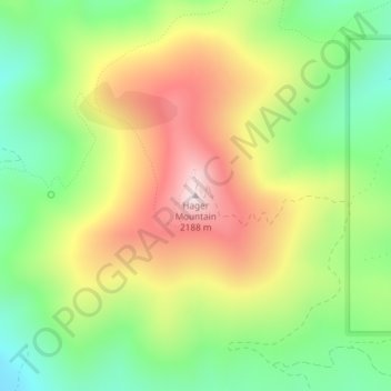
Name: Topografische Karte Hager Mountain, Höhe, Relief.
Ort: Hager Mountain, Lake County, Oregon, United States (43.00937 -121.03168 43.00947 -121.03158)
Durchschnittliche Höhe: 1’882 m
Minimale Höhe: 1’640 m
Maximale Höhe: 2’183 m
Spenden
Rüste dich für dein nächstes Abenteuer:
Als Amazon-Partner verdient diese Seite an qualifizierten Käufen, ohne dass Ihnen zusätzliche Kosten entstehen.
Andere topografische Karten
Klicken Sie auf eine Karte, um ihre Topografie, ihre Höhe und ihr Relief anzuzeigen.
Paisley
United States > Oregon > Lake County
Paisley is located at an elevation of 4,374 feet (1,333 m). According to the United States Census Bureau, the city has a total area of 0.44 square miles (1.14 km2), all of it land. The Chewaucan River flows through the city.
Durchschnittliche Höhe: 1’355 m
Summer Lake
United States > Oregon > Lake County
Summer Lake was spotted and named by Captain John C. Frémont during his 1843 mapping expedition through central Oregon. Fremont and his Army topographical team were mapping the Oregon Territory from The Dalles on Columbia River to Sutter's Fort in Sacramento, California. On 16 December 1843, the expedition…
Durchschnittliche Höhe: 1’409 m
Lakeview
United States > Oregon > Lake County
Lakeview is a city in Lake County, Oregon, United States. The population was 2,418 at the 2020 census. It is the county seat of Lake County. The city bills itself as the "Tallest Town in Oregon" because of its elevation, 4,757 feet (1,450 m) above sea level. Lakeview is situated in the Goose Lake Valley at the…
Durchschnittliche Höhe: 1’562 m
Valley Falls
United States > Oregon > Lake County
In 1832, John Work led his Hudson's Bay Company trapping brigade through the Valley Falls area. Work recorded the visit in his journal. In 1843, Captain John C. Fremont explored the area around Valley Falls. Fremont name Abert Rim and nearby Abert Lake after the head of the United States Army's topographical…
Durchschnittliche Höhe: 1’324 m
Spenden
Rüste dich für dein nächstes Abenteuer:
Als Amazon-Partner verdient diese Seite an qualifizierten Käufen, ohne dass Ihnen zusätzliche Kosten entstehen.
Hart Mountain National Antelope Refuge
United States > Oregon > Lake County
Durchschnittliche Höhe: 1’594 m
Spenden
Rüste dich für dein nächstes Abenteuer:
Als Amazon-Partner verdient diese Seite an qualifizierten Käufen, ohne dass Ihnen zusätzliche Kosten entstehen.