
Topografische Karte Dobrogea
Interaktive Karte
Klicken Sie auf die Karte, um die Höhe anzuzeigen.
Über diese Karte
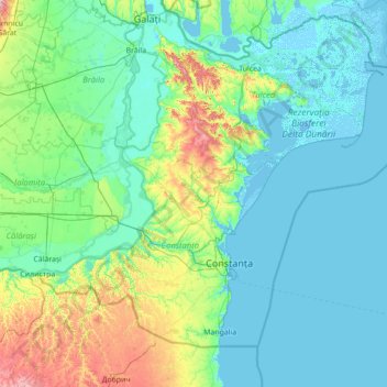
Name: Topografische Karte Dobrogea, Höhe, Relief.
Ort: Dobrogea, Grădina, Constanța, 907277, Romania (43.52455 27.39217 45.52455 29.39217)
Durchschnittliche Höhe: 53 m
Minimale Höhe: -4 m
Maximale Höhe: 478 m
Except for the Danube Delta, a marshy region located in its northeastern corner, Dobruja is hilly, with an average altitude of about 200–300 metres. The highest point is the Țuțuiatu (Greci) Peak in the Măcin Mountains, having a height of 467 m. The Dobruja Plateau covers most of the Romanian part of Dobruja. The Ludogorie Plateau is found in Bulgaria. Lake Razelm is one of the most important lakes in Northern Dobruja.