
Topografische Karte Houston
Interaktive Karte
Klicken Sie auf die Karte, um die Höhe anzuzeigen.
Über diese Karte
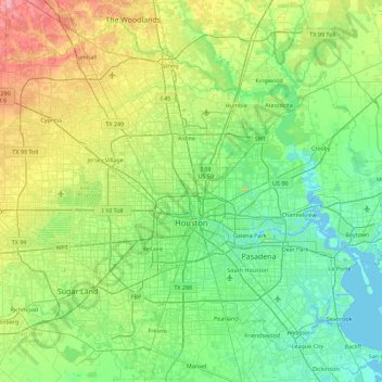
Name: Topografische Karte Houston, Höhe, Relief.
Ort: Houston, Harris County, Texas, United States (29.53707 -95.90974 30.11035 -95.01205)
Durchschnittliche Höhe: 25 m
Minimale Höhe: -3 m
Maximale Höhe: 98 m
Much of the city was built on forested land, marshes, or swamps, and all are still visible in surrounding areas. Flat terrain and extensive greenfield development have combined to worsen flooding. Downtown stands about 50 feet (15 m) above sea level, and the highest point in far northwest Houston is about 150 feet (46 m) in elevation. The city once relied on groundwater for its needs, but land subsidence forced the city to turn to ground-level water sources such as Lake Houston, Lake Conroe, and Lake Livingston. The city owns surface water rights for 1.20 billion US gallons (4.5 Gl) of water a day in addition to 150 million US gallons (570 Ml) a day of groundwater.
Andere topografische Karten
Klicken Sie auf eine Karte, um ihre Topografie, ihre Höhe und ihr Relief anzuzeigen.
Pasadena
United States > Texas > Harris County
Pasadena, Harris County, Texas, United States
Durchschnittliche Höhe: 11 m
Jersey Village
United States > Texas > Harris County
Jersey Village, Harris County, Texas, United States
Durchschnittliche Höhe: 35 m
Spring
United States > Texas > Harris County > Spring
Spring, Harris County, Texas, 77373:77388, United States
Durchschnittliche Höhe: 35 m
Cypress
United States > Texas > Harris County
Cypress, Harris County, Texas, 77433, United States
Durchschnittliche Höhe: 46 m
Croyden Gardens Park
United States > Texas > Harris County > Houston
Croyden Gardens Park, 8400, Houston, Harris County, Texas, 77093, United States
Durchschnittliche Höhe: 21 m
Seabrook
United States > Texas > Harris County
Seabrook, Harris County, Texas, 77586, United States
Durchschnittliche Höhe: 3 m