
Topografische Karte Villa Rica
Interaktive Karte
Klicken Sie auf die Karte, um die Höhe anzuzeigen.
Über diese Karte
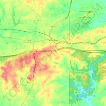
Name: Topografische Karte Villa Rica, Höhe, Relief.
Ort: Villa Rica, Carroll County, Georgia, 30180, United States (33.68193 -84.97237 33.76000 -84.86267)
Durchschnittliche Höhe: 338 m
Minimale Höhe: 281 m
Maximale Höhe: 410 m
Andere topografische Karten
Klicken Sie auf eine Karte, um ihre Topografie, ihre Höhe und ihr Relief anzuzeigen.
Mount Zion
United States > Georgia > Carroll County
Mount Zion, Carroll County, Georgia, United States
Durchschnittliche Höhe: 356 m
Carrollton
United States > Georgia > Carroll County
Carrollton, Carroll County, Georgia, United States
Durchschnittliche Höhe: 329 m
Bowdon
United States > Georgia > Carroll County
Bowdon, Carroll County, Georgia, 30108, United States
Durchschnittliche Höhe: 319 m