
Topografische Karte Kenilworth
Interaktive Karte
Klicken Sie auf die Karte, um die Höhe anzuzeigen.
Über diese Karte
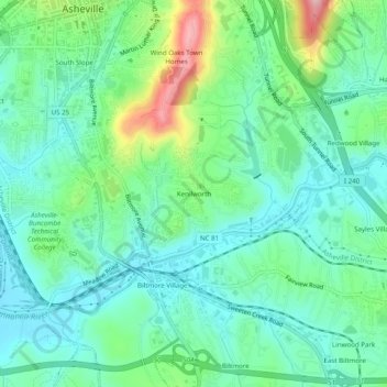
Name: Topografische Karte Kenilworth, Höhe, Relief.
Durchschnittliche Höhe: 648 m
Minimale Höhe: 599 m
Maximale Höhe: 784 m
Andere topografische Karten
Klicken Sie auf eine Karte, um ihre Topografie, ihre Höhe und ihr Relief anzuzeigen.
Biltmore Village
United States > North Carolina > Buncombe County > Asheville
Biltmore Village, Asheville, Buncombe County, North Carolina, 28802, United States
Durchschnittliche Höhe: 642 m
Albemarle
United States > North Carolina > Buncombe County > Asheville
Albemarle, Asheville, Buncombe County, North Carolina, 28802, United States
Durchschnittliche Höhe: 718 m
Royal Pines
United States > North Carolina > Buncombe County > Asheville
Royal Pines, Asheville, Buncombe County, North Carolina, 28776, United States
Durchschnittliche Höhe: 700 m
Biltmore
United States > North Carolina > Buncombe County > Asheville
Biltmore, Asheville, Buncombe County, North Carolina, 28803, United States
Durchschnittliche Höhe: 650 m
Redwood Village
United States > North Carolina > Buncombe County > Asheville
Redwood Village, Asheville, Buncombe County, North Carolina, 28805, United States
Durchschnittliche Höhe: 657 m
Aston Park
United States > North Carolina > Buncombe County > Asheville > River Arts District
Aston Park, River Arts District, Asheville, Buncombe County, North Carolina, 28801, United States
Durchschnittliche Höhe: 641 m
Deaver View
United States > North Carolina > Buncombe County > Asheville
Deaver View, Asheville, Buncombe County, North Carolina, 28806, United States
Durchschnittliche Höhe: 678 m