
Spenden
Rüste dich für dein nächstes Abenteuer:
Als Amazon-Partner verdient diese Seite an qualifizierten Käufen, ohne dass Ihnen zusätzliche Kosten entstehen.
Topografische Karte Columbia
Klicken Sie auf die Karte, um die Höhe anzuzeigen.
Spenden
Rüste dich für dein nächstes Abenteuer:
Als Amazon-Partner verdient diese Seite an qualifizierten Käufen, ohne dass Ihnen zusätzliche Kosten entstehen.
Columbia
The primary landforms in Columbia are rolling hills and stream valleys; Columbia's road network is laid out to follow the terrain, with many winding streets and cul-de-sacs. Elevations range from about 200 to 500 feet (61 to 152 m) above sea level. Most of Columbia is drained by the Middle Patuxent and Little Patuxent rivers. There are three artificial lakes, created by damming of tributary streams during community construction. In 1965, the Rouse Company leased 7,000 acres (2,800 ha) of farmland staged for development, and earmarked 4,000 acres (1,600 ha) of oak forest for timber harvesting. The company developed a sapling planter to replant sections of cleared land that would use Columbia's W.R. Grace-developed fertilizers. An outer ring of greenspace was abandoned early in the project because the combination with the already required river buffers would have reduced profitable land available for building. Along with Symphony Woods, many other stands of mature trees have been temporarily maintained in Columbia, including the large Middle Patuxent Environmental Area in the western part of the community between Harper's Choice and River Hill villages, protecting much of the river valley from development.
Spenden
Rüste dich für dein nächstes Abenteuer:
Als Amazon-Partner verdient diese Seite an qualifizierten Käufen, ohne dass Ihnen zusätzliche Kosten entstehen.
Über diese Karte
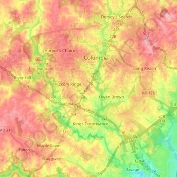
Name: Topografische Karte Columbia, Höhe, Relief.
Ort: Columbia, Howard County, Maryland, United States (39.14766 -76.94691 39.24001 -76.78697)
Durchschnittliche Höhe: 114 m
Minimale Höhe: 44 m
Maximale Höhe: 165 m
Spenden
Rüste dich für dein nächstes Abenteuer:
Als Amazon-Partner verdient diese Seite an qualifizierten Käufen, ohne dass Ihnen zusätzliche Kosten entstehen.
Andere topografische Karten
Klicken Sie auf eine Karte, um ihre Topografie, ihre Höhe und ihr Relief anzuzeigen.