
Spenden
Rüste dich für dein nächstes Abenteuer:
Als Amazon-Partner verdient diese Seite an qualifizierten Käufen, ohne dass Ihnen zusätzliche Kosten entstehen.
Topografische Karte Galtymore
Klicken Sie auf die Karte, um die Höhe anzuzeigen.
Spenden
Rüste dich für dein nächstes Abenteuer:
Als Amazon-Partner verdient diese Seite an qualifizierten Käufen, ohne dass Ihnen zusätzliche Kosten entstehen.
Galtymore
Galtymore or Galteemore (Irish: Cnoc Mór na nGaibhlte, meaning 'big hill of the Galtees') is a mountain in the province of Munster, Ireland. At 917.9 metres (3,011 ft 6 in), it is one of Ireland's highest mountains, being the 12th-highest on the Arderin list, and 14th-highest on the Vandeleur-Lynam list. Galtymore has the 4th-highest topographic prominence of any peak in Ireland, which classifies Galtymore as a P600, or "major mountain". It is one of the 13 Irish Munros.
Spenden
Rüste dich für dein nächstes Abenteuer:
Als Amazon-Partner verdient diese Seite an qualifizierten Käufen, ohne dass Ihnen zusätzliche Kosten entstehen.
Über diese Karte
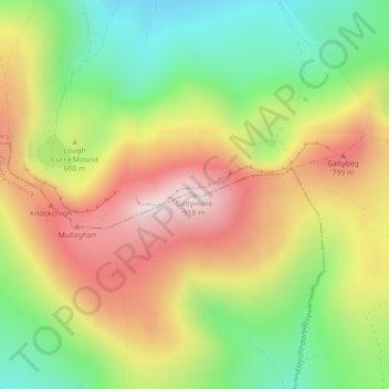
Name: Topografische Karte Galtymore, Höhe, Relief.
Durchschnittliche Höhe: 594 m
Minimale Höhe: 308 m
Maximale Höhe: 904 m
Spenden
Rüste dich für dein nächstes Abenteuer:
Als Amazon-Partner verdient diese Seite an qualifizierten Käufen, ohne dass Ihnen zusätzliche Kosten entstehen.
Andere topografische Karten
Klicken Sie auf eine Karte, um ihre Topografie, ihre Höhe und ihr Relief anzuzeigen.
Kilmallock
Ireland > County Limerick > The Municipal District of Cappamore — Kilmallock
Durchschnittliche Höhe: 89 m
Kilmurry
Ireland > County Limerick > The Municipal District of Cappamore — Kilmallock
Durchschnittliche Höhe: 90 m
Kilfinnane
Ireland > County Limerick > The Municipal District of Cappamore — Kilmallock
At an elevation of over 150 metres (500 ft), Kilfinnane is the highest town in County Limerick. It is surrounded on three sides by the Ballyhoura Mountains, and on the fourth side is the "Golden Vale" region that runs through Counties Limerick, Cork, and Tipperary.
Durchschnittliche Höhe: 160 m
Darranstown
Ireland > County Limerick > The Municipal District of Cappamore — Kilmallock
Durchschnittliche Höhe: 108 m
Spenden
Rüste dich für dein nächstes Abenteuer:
Als Amazon-Partner verdient diese Seite an qualifizierten Käufen, ohne dass Ihnen zusätzliche Kosten entstehen.
Ballylanders
Ireland > County Limerick > The Municipal District of Cappamore — Kilmallock
Durchschnittliche Höhe: 157 m
Knockainy
Ireland > County Limerick > The Municipal District of Cappamore — Kilmallock
Durchschnittliche Höhe: 86 m
Drombane
Ireland > County Limerick > The Municipal District of Cappamore — Kilmallock
Durchschnittliche Höhe: 50 m
Aherlow
Ireland > County Limerick > The Municipal District of Cappamore — Kilmallock
Durchschnittliche Höhe: 141 m
Spenden
Rüste dich für dein nächstes Abenteuer:
Als Amazon-Partner verdient diese Seite an qualifizierten Käufen, ohne dass Ihnen zusätzliche Kosten entstehen.
Clare Glens
Ireland > County Limerick > The Municipal District of Cappamore — Kilmallock
Durchschnittliche Höhe: 124 m
Glenstal
Ireland > County Limerick > The Municipal District of Cappamore — Kilmallock
Durchschnittliche Höhe: 147 m
Coolattin
Ireland > County Limerick > The Municipal District of Cappamore — Kilmallock
Durchschnittliche Höhe: 222 m
Caherconlish
Ireland > County Limerick > The Municipal District of Cappamore — Kilmallock
Durchschnittliche Höhe: 79 m
Spenden
Rüste dich für dein nächstes Abenteuer:
Als Amazon-Partner verdient diese Seite an qualifizierten Käufen, ohne dass Ihnen zusätzliche Kosten entstehen.
Coolfree
Ireland > County Limerick > The Municipal District of Cappamore — Kilmallock
Durchschnittliche Höhe: 254 m
Tobernea
Ireland > County Limerick > The Municipal District of Cappamore — Kilmallock
Durchschnittliche Höhe: 93 m
Anglesborough
Ireland > County Limerick > The Municipal District of Cappamore — Kilmallock
Durchschnittliche Höhe: 229 m
Barna
Ireland > County Limerick > The Municipal District of Cappamore — Kilmallock
Durchschnittliche Höhe: 249 m
Spenden
Rüste dich für dein nächstes Abenteuer:
Als Amazon-Partner verdient diese Seite an qualifizierten Käufen, ohne dass Ihnen zusätzliche Kosten entstehen.
Dromin
Ireland > County Limerick > The Municipal District of Cappamore — Kilmallock
Durchschnittliche Höhe: 73 m
Garranbane
Ireland > County Limerick > The Municipal District of Cappamore — Kilmallock
Durchschnittliche Höhe: 143 m
Ballyvalode
Ireland > County Limerick > The Municipal District of Cappamore — Kilmallock
Durchschnittliche Höhe: 66 m
Ballysallagh
Ireland > County Limerick > The Municipal District of Cappamore — Kilmallock
Durchschnittliche Höhe: 80 m
Spenden
Rüste dich für dein nächstes Abenteuer:
Als Amazon-Partner verdient diese Seite an qualifizierten Käufen, ohne dass Ihnen zusätzliche Kosten entstehen.
Knocknascrow
Ireland > County Limerick > The Municipal District of Cappamore — Kilmallock
Durchschnittliche Höhe: 306 m
Tullabeg
Ireland > County Limerick > The Municipal District of Cappamore — Kilmallock
Durchschnittliche Höhe: 67 m
Oola
Ireland > County Limerick > The Municipal District of Cappamore — Kilmallock
Durchschnittliche Höhe: 77 m
Nicker
Ireland > County Limerick > The Municipal District of Cappamore — Kilmallock
Durchschnittliche Höhe: 83 m
Spenden
Rüste dich für dein nächstes Abenteuer:
Als Amazon-Partner verdient diese Seite an qualifizierten Käufen, ohne dass Ihnen zusätzliche Kosten entstehen.
Kilmallock
Ireland > County Limerick > The Municipal District of Cappamore — Kilmallock
Durchschnittliche Höhe: 90 m
Ballyshoneen
Ireland > County Limerick > The Municipal District of Cappamore — Kilmallock
Durchschnittliche Höhe: 79 m
Muingacree
Ireland > County Limerick > The Municipal District of Cappamore — Kilmallock
Durchschnittliche Höhe: 268 m
Kilflynn Particles Parish Union
Ireland > County Limerick > The Municipal District of Cappamore — Kilmallock
Durchschnittliche Höhe: 211 m
Spenden
Rüste dich für dein nächstes Abenteuer:
Als Amazon-Partner verdient diese Seite an qualifizierten Käufen, ohne dass Ihnen zusätzliche Kosten entstehen.
Toomaline Upper
Ireland > County Limerick > The Municipal District of Cappamore — Kilmallock
Durchschnittliche Höhe: 122 m
Pallasbeg
Ireland > County Limerick > The Municipal District of Cappamore — Kilmallock
Durchschnittliche Höhe: 49 m
Ballinscaula
Ireland > County Limerick > The Municipal District of Cappamore — Kilmallock
Durchschnittliche Höhe: 106 m
Cullane South
Ireland > County Limerick > The Municipal District of Cappamore — Kilmallock
Durchschnittliche Höhe: 152 m
Spenden
Rüste dich für dein nächstes Abenteuer:
Als Amazon-Partner verdient diese Seite an qualifizierten Käufen, ohne dass Ihnen zusätzliche Kosten entstehen.
Coolnahila (Palmer)
Ireland > County Limerick > The Municipal District of Cappamore — Kilmallock
Durchschnittliche Höhe: 39 m
Doon
Ireland > County Limerick > The Municipal District of Cappamore — Kilmallock
Durchschnittliche Höhe: 112 m
Anglesborough
Ireland > County Limerick > The Municipal District of Cappamore — Kilmallock
Durchschnittliche Höhe: 229 m
Brickfield
Ireland > County Limerick > The Municipal District of Cappamore — Kilmallock
Durchschnittliche Höhe: 123 m
Spenden
Rüste dich für dein nächstes Abenteuer:
Als Amazon-Partner verdient diese Seite an qualifizierten Käufen, ohne dass Ihnen zusätzliche Kosten entstehen.
Mounteagle
Ireland > County Limerick > The Municipal District of Cappamore — Kilmallock
Durchschnittliche Höhe: 63 m
Dead
Ireland > County Limerick > The Municipal District of Cappamore — Kilmallock
Durchschnittliche Höhe: 62 m