
Topografische Karte Norfolk
Interaktive Karte
Klicken Sie auf die Karte, um die Höhe anzuzeigen.
Über diese Karte
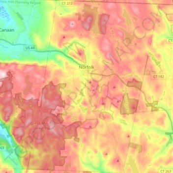
Name: Topografische Karte Norfolk, Höhe, Relief.
Durchschnittliche Höhe: 404 m
Minimale Höhe: 203 m
Maximale Höhe: 559 m
According to the United States Census Bureau, the town has a total area of 46.4 square miles (120.2 km2), of which 45.3 square miles (117.4 km2) are land and 1.1 square miles (2.9 km2), or 2.38%, are water. The town is located in the Litchfield Hills portion of the Appalachian mountain range. Norfolk's elevation is 1,230 feet (370 m) above sea level, and the town is sometimes called "the Icebox of Connecticut" for its severe winters and particularly cool summers.