
Topografische Karte Walhalla
Interaktive Karte
Klicken Sie auf die Karte, um die Höhe anzuzeigen.
Über diese Karte
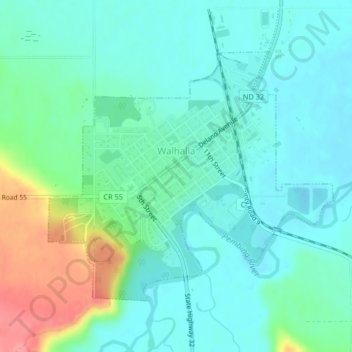
Name: Topografische Karte Walhalla, Höhe, Relief.
Ort: Walhalla, Pembina County, North Dakota, United States (48.91182 -97.93314 48.93093 -97.89982)
Durchschnittliche Höhe: 303 m
Minimale Höhe: 283 m
Maximale Höhe: 363 m
Andere topografische Karten
Klicken Sie auf eine Karte, um ihre Topografie, ihre Höhe und ihr Relief anzuzeigen.
Drayton
United States > North Dakota > Pembina County
Drayton, Pembina County, North Dakota, 58225, United States
Durchschnittliche Höhe: 242 m
Pittsburgh
United States > North Dakota > Pembina County > Pittsburgh
Pittsburgh, Pembina County, North Dakota, United States
Durchschnittliche Höhe: 243 m
Bathgate
United States > North Dakota > Pembina County > Bathgate
Bathgate, Pembina County, North Dakota, United States
Durchschnittliche Höhe: 250 m
Mountain
United States > North Dakota > Pembina County
Mountain, Pembina County, North Dakota, United States
Durchschnittliche Höhe: 325 m